
Image: San Francisco Plan (Burnham, 1905)

Size of this preview: 632 × 599 pixels. Other resolutions: 253 × 240 pixels | 9,928 × 9,416 pixels.
Original image (9,928 × 9,416 pixels, file size: 200.69 MB, MIME type: image/png)
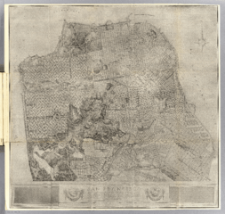
Description: San Francisco: Plan, showing system of highways, public places, parks, park connections, etc. To serve as a guide for the future development of the city. Recommended in his report to the Association for the Improvement and Adornment of San Francisco, by D.H. Burnham.
Title: San Francisco Plan (Burnham, 1905)
Credit: David Rumsey Historical Map Collection, originally published September 1905: Report on a plan for San Francisco. Association for the Improvement and Adornment of San Francisco (September 1905). Retrieved on 31 January 2017.
Author: Burnham, Daniel H. (1846-1912)
Usage Terms: Public domain
License: Public domain
Attribution Required?: No
Image usage
The following page links to this image:

All content from Kiddle encyclopedia articles (including the article images and facts) can be freely used under Attribution-ShareAlike license, unless stated otherwise.
.png)