
Image: Sands Point, NJ

Size of this preview: 800 × 318 pixels. Other resolutions: 320 × 127 pixels | 2,746 × 1,090 pixels.
Original image (2,746 × 1,090 pixels, file size: 857 KB, MIME type: image/jpeg)
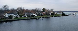
Description: Photo showing a part of Sands Point, New Jersey, an unincorporated community within Oceanport and the Branchport Creek. Photo taken looking north from a bridge connecting Monmouth Boulevard (Oceanport) and Florence Avenue (Long Branch) also known as County Route 33.
Title: Sands Point, NJ
Credit: Own work
Author: Mr. Matté (if there is an issue with this image, contact me using this image's Commons talk page or my English Wikipedia talk page; I'll know about it a lot faster)
Usage Terms: Creative Commons Attribution 4.0
License: CC BY 4.0
License Link: http://creativecommons.org/licenses/by/4.0
Attribution Required?: Yes
Image usage
There are no pages that link to this image.

All content from Kiddle encyclopedia articles (including the article images and facts) can be freely used under Attribution-ShareAlike license, unless stated otherwise.