
Image: Scilly naval disaster 1707 Track

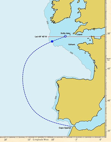
Description: The dashed blue line shows the approximate route of the fleet under the command of Admiral Shovell from Cape Spartel to the Isles of Scilly October 1707. The open circle shows the dead reckoning position of H.M.S. Orford when it hove to, with the rest of the fleet, before they set off on the fatal last stage of the voyage. The position is from the log kept by Lieutenant Anthony Lochard, published by William May ( (1960). "The Last Voyage of Sir Clowdisley Shovel". The Journal of Navigation 13 (3): 324-332.). HMS Orford avoided the disaster in which four ships were lost, and Shovell and some 2,000 sailors died, when they struck the Gilstone rocks in the Scillies. The red horizontal line shows latitude 49° 40’ N, recommended by Edmund Halley ( (1700). "An Advertisement Necessary for All Navigatiors Bound up the Channel of England". Philosophical Transactions 22: 725-726.) as a safe northern limit for entering the channel and clearing the Isles of Scilly and the Lizard. Data superimposed on file: Outline map Atlantic Coast Morocco to Ireland.jpg
Title: Scilly naval disaster 1707 Track
Credit: Own work
Author: Kognos
Usage Terms: Creative Commons Attribution-Share Alike 4.0
License: CC BY-SA 4.0
License Link: https://creativecommons.org/licenses/by-sa/4.0
Attribution Required?: Yes
Image usage
The following page links to this image:
