
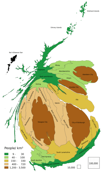
Image: Scotland population cartogram

Size of this PNG preview of this SVG file: 373 × 600 pixels. Other resolution: 149 × 240 pixels.
Original image (SVG file, nominally 677 × 1,089 pixels, file size: 251 KB)
Description: Scotland population cartogram. Sizes of council area are approximately in proportion to their population - error standard deviation 4 %.
Title: Scotland population cartogram
Credit: Own work based on: Population Estimates for UK, England and Wales, Scotland and Northern Ireland - Office for National Statistics, 2015 Local Authority Districts (December 2016) Ultra Generalised Clipped Boundaries in Great Britain ONS Geography Linked Data Portal, under the Open Government Licence v3.0 (OGL v.3)
Author: PawełS
Usage Terms: Creative Commons Attribution-Share Alike 4.0
License: CC BY-SA 4.0
License Link: http://creativecommons.org/licenses/by-sa/4.0
Attribution Required?: Yes
Image usage
The following page links to this image:

All content from Kiddle encyclopedia articles (including the article images and facts) can be freely used under Attribution-ShareAlike license, unless stated otherwise.