
Image: Shattering isochamend

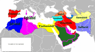
Description: Isochronic map of Caliphate fragmentation
Title: Shattering isochamend
Credit: self-made derived from http://www.maproom.org/00/46/present.php?m=0082 Plate 82 from Hand-Atlas für die Geschichte des Mittelalters und die neueren Zeit by Spruner and Menke Index no. 0046:0082 The lands of Islam to the time of the Buyids, 945-1055. Southern Arabia. (Western continuation of the main map.) The Ghaznavid Empire about 1002/3. The Eastern Roman Empire about 1002/3. — Die Länder des Islâm zur Zeit der Bûjiden 945-1055. Südliches Arabien. Reich der Ghazneviden um 1002/3. Oströmisches Reich 1021 bis 1055 http://www.maproom.org/00/08/present.php?m=0077 Plate 77 from Professor G. Droysens Allgemeiner Historischer Handatlas by R. Andree Index no. 0008:0077 The Caliphate, to 945 — Reich der Kalifen bis 945
Author: Busterof666
Usage Terms: Public domain
License: Public domain
Attribution Required?: No
Image usage
The following page links to this image:
