
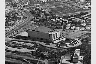
Image: Sheikh Badr and Jerusalem Convention Center from the air

Size of this preview: 800 × 533 pixels. Other resolutions: 320 × 213 pixels | 1,920 × 1,280 pixels.
Original image (1,920 × 1,280 pixels, file size: 723 KB, MIME type: image/jpeg)
Description: An aerial picture of the Sheikh Badr neighbourhood (top half) and the Jerusalem Convention Center (Binyenei HaUma) shortly after completion, circa 1960. At the time, the Arab Sheikh Badr neighbourhood was used as the head office of the state of Israel Ministry of Foreign Affairs. In the 2000's the remaining houses of Sheikh Badr were completely demolished and a new housing development, Mishkenot Ha'uma, built in its place.
Title: Sheikh Badr and Jerusalem Convention Center from the air
Credit: Israel State Archive
Author: Unknown authorUnknown author
Usage Terms: Public domain
License: Public domain
Attribution Required?: No
Image usage
The following page links to this image:

All content from Kiddle encyclopedia articles (including the article images and facts) can be freely used under Attribution-ShareAlike license, unless stated otherwise.