
Image: SiegeOfFortStanwix1777FleuryMap

Size of this preview: 800 × 529 pixels. Other resolutions: 320 × 212 pixels | 6,184 × 4,088 pixels.
Original image (6,184 × 4,088 pixels, file size: 5.53 MB, MIME type: image/jpeg)
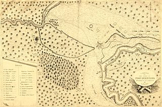
Description: Caption: Sketch of the siege of Fort Schuyler, Presented to Col. Gansevoort by L. Flury This map depicts the positions and movements at the 1777 Siege of Fort Stanwix (also known as Fort Schuyler). The map has had its edges cropped, and the image has been contrast-adjusted.
Title: SiegeOfFortStanwix1777FleuryMap
Credit: From the University of Pittsburgh digital collection.
Author: Francois Louis Tesseidre de Fleury
Usage Terms: Public domain
License: Public domain
Attribution Required?: No
Image usage
The following 2 pages link to this image:

All content from Kiddle encyclopedia articles (including the article images and facts) can be freely used under Attribution-ShareAlike license, unless stated otherwise.