
Image: Siege of Lexington hospital map
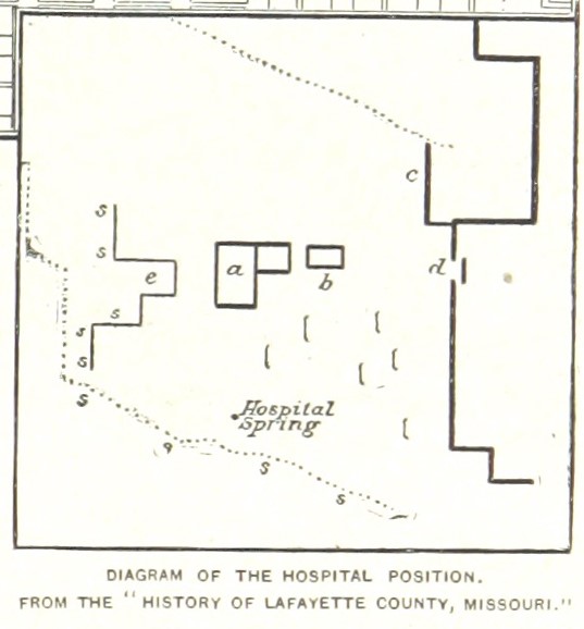
Description: A map of the area around the Anderson House during the First Battle of Lexington. Original description: Explanation of the Diagram of the Hospital Position : a is the Anderson house or hospital ; b a smaller brick house back of it ; c an outlying low earthwork, projecting down nearly into the ravine, represented by the dotted line, while the inclosed earthwork was built up around the head of the ravine, as shown by the plain line ; d the sally-port in the earthworks, about one hundred yards from the hospital ; e a canal-like carriageway leading up to the house, and in which the sharp-shooters lay secure, only about eighty feet from the front door of the hospital; the brackets represent Federal picket-guard stations with a little dirt thrown up for protection; the dotted line sss shows deep gorge or ravine which was full of Confederate sharp-shooters."
Title: Siege of Lexington hospital map
Credit: This file is from the Mechanical Curator collection, a set of over 1 million images scanned from out-of-copyright books and released to Flickr Commons by the British Library. View in BL Georeferencer View image on Flickr View all images from book View catalogue entry for book.
Author: Robert Underwood Johnson and Clarence Clough Buel (Book authors).
Usage Terms: Public domain
License: Public domain
Attribution Required?: No
Image usage
The following page links to this image:
