
Image: Siege of Lexington map

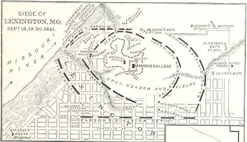
Description: A map of the last three days of the First Battle of Lexington during the Civil War. In the original book, this description followed the map:"Captain Joseph A. Wilson, of Lexington, thus describes the Union position: "' The college is on a bluff about 200 feet above low-water mark, and from 15 to 30 feet higher than North or Main street. Third street runs along the top of the bluff. Close to and surrounding the college building was a rectangular fort of sods and earth about 12 feet thick and 12 feet high ; with bastions at the angles and embrasures for guns. At a distance of 200 to 800 feet was an irregular line of earthworks protected by numerous traverses, occasional redoubts, a good ditch, trous-de-loup, wires, etc., etc. Still farther on the west and north were rifle-pits. The works would have required 10,000 or 15,000 men to occupy them fully. All the ground from the fortifications to the river was then covered with scattering timber. The spring just north and outside of fortifications, was in a deep wooded ravine, and was the scene of some sharp skirmishing at night, owing to the attempts of the garrison to get water there when their cisterns gave out."
Title: Siege of Lexington map
Credit: This file is from the Mechanical Curator collection, a set of over 1 million images scanned from out-of-copyright books and released to Flickr Commons by the British Library. View in BL Georeferencer View image on Flickr View all images from book View catalogue entry for book.
Author: Robert Underwood Johnson and Clarence Clough Buel (Book authors).
Usage Terms: Public domain
License: Public domain
Attribution Required?: No
Image usage
The following page links to this image:
