
Image: Snetterton 1965 annotated

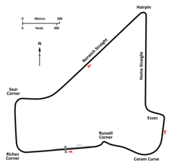
Description: An annotated diagrammatic map of the Snetterton Circuit as it was configured circa 1965, in approximately its original form but with the addition of the open chicane at Russell in place of Paddock Bend, immediately prior to the shortening of the circuit in 1966. Circuit cartography is derived from RAF and USAAF aerial photography taken in 1946-1947 and contemporary Ordnance Survey plans. Circuit layout and corner names are per diagrams printed in contemporary race programs.
Title: Snetterton 1965 annotated
Credit: Own work
Author: John Chapman
Usage Terms: Creative Commons Attribution-Share Alike 4.0
License: CC BY-SA 4.0
License Link: https://creativecommons.org/licenses/by-sa/4.0
Attribution Required?: Yes
Image usage
The following page links to this image:
