
Image: Snetterton Circuit versus RAF Snetterton

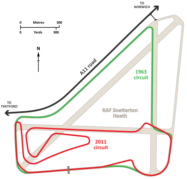
Description: A diagrammatic map describing the development of the Snetterton motor racing circuit. Snetterton was laid out in the early 1950s on the runways and taxiways of the former RAF Snetterton Heath air base (shown in pale brown). As initially configured, the circuit (shown in green) was 2.71 miles (4.36 kilometres) in length and utilized long stretches of the taxiway that ran parallel to the A11 road, and the N-S runway. The start/finish straight was positioned on the southern taxiway, where it remains to this day. This configuration lasted until the 1965, when a tight chicane was introduced just ahead of the starting straight. This chicane was reduced to an open kink in late 1966, which lasted for many years. In 1974 the circuit was shortened to approximately 1.9 miles (3.1 kilometres) in length and reworked. The northern portion was bypassed by a new straight using the previously redundant E-W runway, although the track was retained for occasional use. The Esses were repositioned to maintain the same right-left geometry as previously, but turned through nearly 90 degrees to line up with the new straight. Initially, the new Esses complex was open and fast, but owing to a number of accidents it was tightened at the end of the 1974 season. To date, this was the longest-lived configuration of the Snetterton Circuit, and apart from adjustments to the chicane preceding the starting straight it remained essentially unchanged until 2011. In 2011, the circuit was extensively redeveloped and a new infield portion was constructed to extend the main 300 Circuit (shown in red) length to 2.97 miles (4.78 kilometres). Despite operating as a racing circuit for over 60 years, including major redevopments, in this form the Snetterton Circuit still largely conforms to the geometry imposed by the old airfield. Cartography for the 1963 circuit, the airfield's runways and taxiways, and the A11 access road were derived from RAF and USAAF aerial photography taken in 1946-1947 and contemporary Ordnance Survey plans. The 2011 circuit was derived from aerial photography available from a number of internet mapping sources.
Title: Snetterton Circuit versus RAF Snetterton
Credit: Own work
Author: John Chapman
Usage Terms: Creative Commons Attribution-Share Alike 4.0
License: CC BY-SA 4.0
License Link: https://creativecommons.org/licenses/by-sa/4.0
Attribution Required?: Yes
Image usage
The following page links to this image:
