
Image: South West Trains route map 2010

Size of this PNG preview of this SVG file: 790 × 599 pixels. Other resolution: 316 × 240 pixels.
Original image (SVG file, nominally 999 × 758 pixels, file size: 859 KB)
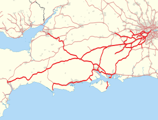
Description: Map showing railway routes operated by South West Trains in 2010. The background map shows the coast of England and Wales and major urban areas. Equirectangular map projection on WGS 84 datum, with N/S stretched 160%
Title: South West Trains route map 2010
Credit: Ordnance Survey OpenData. Great Britain coastline and boundary data from Boundary-Line product. Railway route and urban area data from Meridian 2 product.
Author: Nilfanion
Usage Terms: Creative Commons Attribution-Share Alike 3.0
License: CC BY-SA 3.0
License Link: http://creativecommons.org/licenses/by-sa/3.0
Attribution Required?: Yes
Image usage
The following page links to this image:

All content from Kiddle encyclopedia articles (including the article images and facts) can be freely used under Attribution-ShareAlike license, unless stated otherwise.