
Image: Strathoykel at Tuiteam Tarbhach

Size of this preview: 800 × 598 pixels. Other resolutions: 320 × 239 pixels | 2,866 × 2,144 pixels.
Original image (2,866 × 2,144 pixels, file size: 2.66 MB, MIME type: image/jpeg)
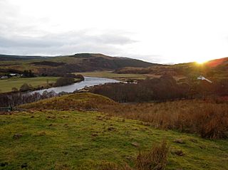
Description: View of Strathoykel in northern Scotland looking west (upstream) from Tutim cemetery at sunset. The cemetery wall is in the foreground, Brae farm on the left of the photo, and Tuiteam house on the right. The mouth of the Tutim Burn can be seen entering the River Oykel roughly level with Tuiteam house. The hill is Ben Chreagach. The site is notable for the en:Battle of Tuiteam Tarbhach which took place around Tuiteam house in about 1406.
Title: Strathoykel at Tuiteam Tarbhach
Credit: Own work
Author: Le Deluge
Usage Terms: Creative Commons Attribution-Share Alike 3.0
License: CC BY-SA 3.0
License Link: https://creativecommons.org/licenses/by-sa/3.0
Attribution Required?: Yes
Image usage
The following page links to this image:

All content from Kiddle encyclopedia articles (including the article images and facts) can be freely used under Attribution-ShareAlike license, unless stated otherwise.