
Image: Summit Level of Morris Canal from HABS

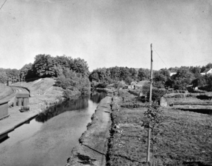
Description: Pic of summit level. HABS says: 48. SUMMIT OF THE MORRIS CANAL, 914 FEET ABOVE MEAN HIGH TIDE AT NEWARK, NEW JERSEY. TRACKS OF THE D, L & W RAILROAD CAN BE SEEN AT LEFT. EDGE OF THE LAKE HOPATCONG STATION IS ALSO VISIBLE AT LEFT. PASSENGERS AND FREIGHT COULD BE TRANSFERRED TO SMALL BOATS FOR TRANSPORT THROUGH THE FEEDER CANAL TO LAKE HOPATCONG. - Morris Canal, Phillipsburg, Warren County, NJ
Title: Summit Level of Morris Canal from HABS
Credit: This image is available from the United States Library of Congress's Prints and Photographs division under the digital ID hhh.nj0903. This tag does not indicate the copyright status of the attached work. A normal copyright tag is still required. See Commons:Licensing for more information.
Author: Historic American Buildings Survey
Permission: This work is in the public domain in the United States because it is a work prepared by an officer or employee of the United States Government as part of that person’s official duties under the terms of Title 17, Chapter 1, Section 105 of the US Code. Note: This only applies to original works of the Federal Government and not to the work of any individual U.S. state, territory, commonwealth, county, municipality, or any other subdivision. This template also does not apply to postage stamp designs published by the United States Postal Service since 1978. (See § 313.6(C)(1) of Compendium of U.S. Copyright Office Practices). It also does not apply to certain US coins; see The US Mint Terms of Use.
Usage Terms: Public domain
License: Public domain
Attribution Required?: No
Image usage
The following page links to this image:
