
Image: Susquehanna Boom Map

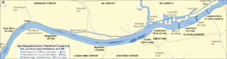
Description: Map of the Susquehanna Boom in the West Branch Susquehanna River in Lycoming County, Pennsylvania, United States, circa 1888
Title: Susquehanna Boom Map
Credit: River and political boundaries taken from US Census website [1], boom crib positions taken from US Government 1938 aerial photographs [2] and information and maps in Thomas T. Taber III's "Williasmport Lumber Capital", canal and river shore positions taken from 1923 United States Geological Survey (US Govt) map [3] and this 1890 Williamsport map [4], which also has the lumber mill ponds. All combined and modified by User:Ruhrfisch.
Author: Ruhrfisch
Permission: US Census / US Government work is public domain, 1890 map is public domain, my modifications licensed under the GNU Free Documentation License
Usage Terms: Creative Commons Attribution-Share Alike 3.0
License: CC-BY-SA-3.0
License Link: http://creativecommons.org/licenses/by-sa/3.0/
Attribution Required?: Yes
Image usage
The following page links to this image:
