
Image: Taiping Heavenly Kingdom map

Size of this PNG preview of this SVG file: 790 × 600 pixels. Other resolution: 316 × 240 pixels.
Original image (SVG file, nominally 964 × 732 pixels, file size: 366 KB)
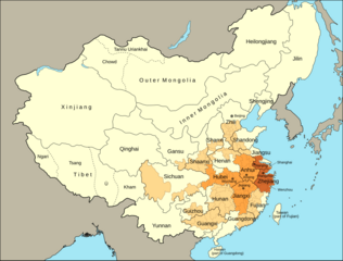
Description: A map showing the extent of the Taiping Heavenly Kingdom
Title: Taiping Heavenly Kingdom map
Credit: Own work based on: Peng, L. (2021). The last guardian of the throne: The regional army in the late Qing dynasty. Journal of Institutional Economics, 17(2), 321-337. doi:10.1017/S1744137420000430 The Taiping Heavenly Kingdom Rebellion and the Blasphemy of Empire, Thomas H. Reilly, page 2, University of Washington Press, ISBN 978-0-295-80192-6 a derivative of File:China 1820 de.svg
Author: M.Bitton
Usage Terms: Creative Commons Attribution-Share Alike 4.0
License: CC BY-SA 4.0
License Link: https://creativecommons.org/licenses/by-sa/4.0
Attribution Required?: Yes
Image usage
The following page links to this image:

All content from Kiddle encyclopedia articles (including the article images and facts) can be freely used under Attribution-ShareAlike license, unless stated otherwise.