
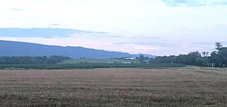
Image: The Civil War battle front Rude's Hill, seen from the viewpoint south of Mt. Jackson, VA

Size of this preview: 800 × 378 pixels. Other resolutions: 320 × 151 pixels | 1,354 × 640 pixels.
Original image (1,354 × 640 pixels, file size: 60 KB, MIME type: image/jpeg)
Description: Rude's Hill, seen from the flatlands of Meems Bottom. This is the viewpoint which Union forces would have in various stime during the war when approaching Confederate forces defending the hill. The Valley Turnipike (now Rt.11) is on he far right.
Title: The Civil War battle front Rude's Hill, seen from the viewpoint south of Mt. Jackson, VA
Credit: Own work
Author: Woodrusher
Usage Terms: Creative Commons Attribution-Share Alike 4.0
License: CC BY-SA 4.0
License Link: https://creativecommons.org/licenses/by-sa/4.0
Attribution Required?: Yes
Image usage
The following page links to this image:

All content from Kiddle encyclopedia articles (including the article images and facts) can be freely used under Attribution-ShareAlike license, unless stated otherwise.