
Image: The Hindu Kush and Passes Between the Kabul and Oxus WDL475

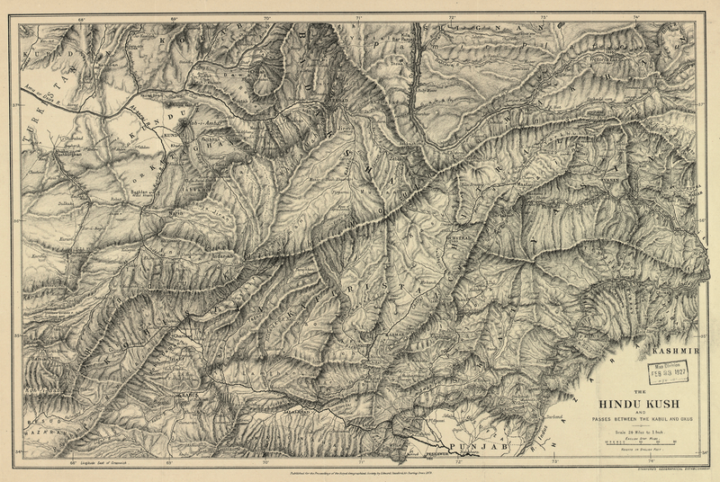
Description: This map originally appeared in the February 1879 issue of the Proceedings of the Royal Geographical Society and Monthly Record of Geography in connection with an article by C.R. Markham entitled “The Upper Basin of the Kabul River.” The Hindu Kush is a range of high mountains that extends some 800 kilometers in a northeast-to-southwest direction from the Pamir Mountains near the Pakistan-China border, through Pakistan, and into western Afghanistan. The range forms the drainage divide between two great river systems, the Amu Darya to the northwest, and the Indus to the southeast. The ancient Greeks called the Amu Darya the Oxus, the name used on this map. The passes through the Hindu Kush historically have been of great military significance. Alexander the Great (356-323 BC) crossed these mountains with his army in 329 BC, most likely over the Khawak Pass, during a campaign to suppress a revolt against his authority in Bactria, an eastern province of the Persian Empire. Hindu Kush Mountains
Title: The Hindu Kush and Passes Between the Kabul and Oxus
Credit: http://dl.wdl.org/475.png Gallery: http://www.wdl.org/en/item/475/
Author: Royal Geographical Society
Usage Terms: Public domain
License: Public domain
Attribution Required?: No
Image usage
There are no pages that link to this image.
