
Image: The Victoria History of the County of Surrey Volume 3 page 481 - Kingston Hundred
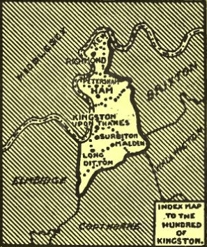
Description: Sketch map of Kingston Hundred showing the River Thames, Kew, Richmond, Petersham, Ham, Kingston upon Thames, Surbiton, Malden and Long Ditton and unmarked but mentioned in the original text in the south-west "Part of Thames Ditton still in the Hundred". West of the river on the left bank is Middlesex. The adjacent hundreds of Brixton and Wallington are marked to the east, Copthorne: south and Elmbridge: south-west. In Middlesex the adjoining hundreds were Spelthorne (which included Teddington and Hampton Wick) and Isleworth (which included Twickenham, and which was like Kingston a small hundred) This map is an illustration cropped from a page scan of The Victoria History of the County of Surrey, Volume 3, page 481 edited by H.E. Malden. The artist is not credited.
Title: The Victoria History of the County of Surrey Volume 3 page 481 - Kingston Hundred
Credit: The Victoria History of the County of Surrey, Volume 3, page 481
Author: H.E. Malden (editor)
Usage Terms: Public domain
License: Public domain
Attribution Required?: No
Image usage
The following page links to this image:
