
Image: Tirana Expansion

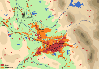
Description: Schematical illustration of the population development (settlement area, commercial zones) in the region of Tirana from 1990 to 2005
Title: Tirana Expansion
Credit: Drawn by myself on the basis of map by Institue for Habitat Development in Besnik Aliaj, Keida Lulo und Genc Myftiu: Tirana - The Challenge of Urban Development (Tirana 2003, ISBN 99927-880-0-3) Google Map satellite pictures Official Albanian Maps 1:50000 of the late 1980ies Literature: Besnik Aliaj, Keida Lulo und Genc Myftiu: Tirana - The Challenge of Urban Development. Tirana 2003, ISBN 99927-880-0-3 Dietmar Richter: Flächennutzungswandel in Tirana. Untersuchungen anhand von Landsat TM, Terra ASTER und GIS. (= Praxis Kultur- und Sozialgeographie; 42). Universitäts-Verlag, Potsdam 2007, ISBN 978-3-939469-64-3 (complete text)
Author: User:Albinfo
Permission: I, the copyright holder of this work, hereby publish it under the following license: This file is licensed under the Creative Commons Attribution-Share Alike 2.5 Generic license. You are free: to share – to copy, distribute and transmit the work to remix – to adapt the work Under the following conditions: attribution – You must attribute the work in the manner specified by the author or licensor (but not in any way that suggests that they endorse you or your use of the work). share alike – If you alter, transform, or build upon this work, you may distribute the resulting work only under the same or similar license to this one. http://creativecommons.org/licenses/by-sa/2.5 CC BY-SA 2.5 Creative Commons Attribution-Share Alike 2.5 truetrue
Usage Terms: Creative Commons Attribution-Share Alike 2.5
License: CC BY-SA 2.5
License Link: http://creativecommons.org/licenses/by-sa/2.5
Attribution Required?: Yes
Image usage
There are no pages that link to this image.
