
Image: Tlaxcalamap

Size of this preview: 768 × 600 pixels. Other resolutions: 307 × 240 pixels | 3,840 × 3,000 pixels.
Original image (3,840 × 3,000 pixels, file size: 2.24 MB, MIME type: image/jpeg)
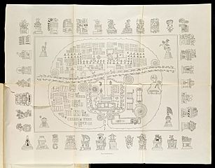
Description: A Map of Tlaxcala: The top-right hand sector is Tizatlan, the bottom-right hand sector Quiahuiztlan, the top-left hand sector Ocotelolco, and the bottom-left hand sector Tepeticpac. The river, Atzompa, crosses the city from North to South (left to right, the map being oriented along an East-West axis).
Title: Tlaxcalamap
Credit: Pinturas Jeroglíficas, Mexico: https://archive.org/details/gri_33125009867314
Author: Alfredo Chavero
Usage Terms: Public domain
License: Public domain
Attribution Required?: No
Image usage
The following page links to this image:

All content from Kiddle encyclopedia articles (including the article images and facts) can be freely used under Attribution-ShareAlike license, unless stated otherwise.