
Image: Tollense Flusssystem
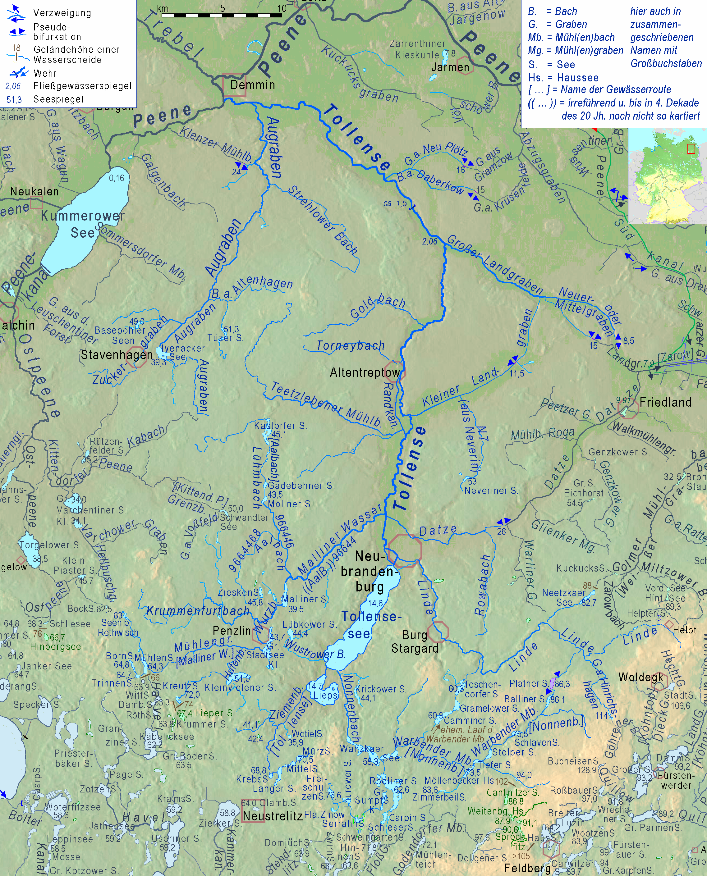
Description: Cutout of the map of the basins of the rivers Peene, Zarow, Recknitz and Ryck; with relief background. name differring from those written in topographic maps haved been collected from water specialists of the maintaining institutions.
Title: Tollense Flusssystem
Credit: adapted cut of File:Peene Flusssystem Relief.png Description This map was created from OpenStreetMap project data, collected by the community. This map may be incomplete, and may contain errors. Don't rely solely on it for navigation. Author OpenStreetMap contributors Date (see file history) Source openstreetmap.org Permission (Reusing this file) OpenStreetMap data is available under the Open Database License (details). Map tiles are licensed under the Creative Commons Attribution-ShareAlike 2.0 license (CC-BY-SA 2.0). Contains map data © OpenStreetMap contributors, made available under the terms of the Open Database License (ODbL). The ODbL does not require any particular license for maps produced from ODbL data; map tiles produced by the OpenStreetMap foundation are licensed under the CC-BY-SA-2.0 licence, but maps produced by other people may be subject to other licences.Open Database LicenseODbLhttp://opendatacommons.org/licenses/odbl/1.0/true This file is licensed under the Creative Commons Attribution-Share Alike 2.0 Generic license. You are free: to share – to copy, distribute and transmit the work to remix – to adapt the work Under the following conditions: attribution – You must give appropriate credit, provide a link to the license, and indicate if changes were made. You may do so in any reasonable manner, but not in any way that suggests the licensor endorses you or your use. share alike – If you remix, transform, or build upon the material, you must distribute your contributions under the same or compatible license as the original. https://creativecommons.org/licenses/by-sa/2.0 CC BY-SA 2.0 Creative Commons Attribution-Share Alike 2.0 truetrue Georeferencing Georeference the map in Wikimaps Warper If inappropriate please set warp_status=skip to hide. & Own work, Source of informations: https://www.lung.mv-regierung.de/insite/cms/umwelt/umweltinformation/gis/kartenportal.htm
Author: Ulamm (talk)
Usage Terms: Creative Commons Attribution-Share Alike 4.0
License: CC BY-SA 4.0
License Link: https://creativecommons.org/licenses/by-sa/4.0
Attribution Required?: Yes
Image usage
The following page links to this image:
