
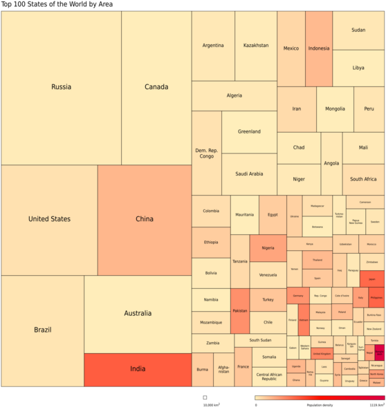
Image: Top100 states area treemap pop-density

Description: Treemap of the world’s top 100 countries sorted by area. Color indicates population density.
Title: Top100 states area treemap pop-density
Credit: Data: CIA World Factbook (visited 2012-09-12); Treemapping: Google Chart Tools visualization API
Author: Own work
Permission: Data: Public domainPublic domainfalsefalse This image is a work of a Central Intelligence Agency employee, taken or made as part of that person's official duties. As a Work of the United States Government, this image or media is in the public domain in the United States. čeština ∙ Deutsch ∙ eesti ∙ English ∙ español ∙ français ∙ italiano ∙ português ∙ polski ∙ sicilianu ∙ slovenščina ∙ suomi ∙ Tiếng Việt ∙ български ∙ македонски ∙ русский ∙ українська ∙ বাংলা ∙ മലയാളം ∙ 한국어 ∙ 日本語 ∙ 中文 ∙ 中文(简体) ∙ 中文(繁體) ∙ العربية ∙ پښتو ∙ +/− Own work: Public domainPublic domainfalsefalse This work is ineligible for copyright and therefore in the public domain because it consists entirely of information that is common property and contains no original authorship.
Usage Terms: Public domain
License: Public domain
Attribution Required?: No
Image usage
The following page links to this image:
