
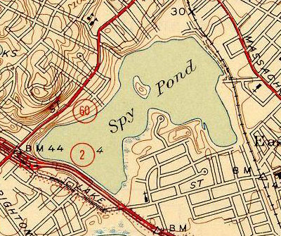
Image: Topographic maps of Spy Pond 1946
No higher resolution available.
Topographic_maps_of_Spy_Pond_1946.jpg (400 × 335 pixels, file size: 88 KB, MIME type: image/jpeg)
Description: Spy Pond and environs. The rail line on the right is now the Minuteman Bikeway.
Title: Topographic maps of Spy Pond 1946
Credit: United States Geological Survey, US Department of the Interior. 1946
Usage Terms: Public domain
License: PD
Attribution Required?: No
Image usage
The following page links to this image:

All content from Kiddle encyclopedia articles (including the article images and facts) can be freely used under Attribution-ShareAlike license, unless stated otherwise.