
Image: Treaty of Sèvres map partitioning Anatolia

Size of this preview: 800 × 577 pixels. Other resolutions: 320 × 231 pixels | 1,024 × 738 pixels.
Original image (1,024 × 738 pixels, file size: 43 KB, MIME type: image/png)
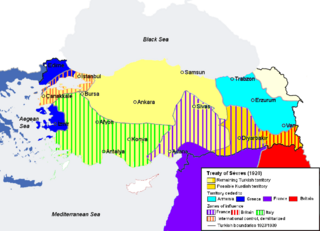
Description: Map illustrating the partitioning of Anatolia according to the Treaty of Sèvres (1920) after World War I.
Title: Treaty of Sèvres map partitioning Anatolia
Credit: Self-made, based on File:TreatyOfSevres.png, corrected according to [1]
Author: Str1977
Usage Terms: Public domain
License: Public domain
Attribution Required?: No
Image usage
The following page links to this image:

All content from Kiddle encyclopedia articles (including the article images and facts) can be freely used under Attribution-ShareAlike license, unless stated otherwise.