
Image: Tree Map of Industries by Share in New York (2014)

Size of this preview: 800 × 228 pixels. Other resolutions: 320 × 91 pixels | 4,776 × 1,362 pixels.
Original image (4,776 × 1,362 pixels, file size: 1.41 MB, MIME type: image/png)
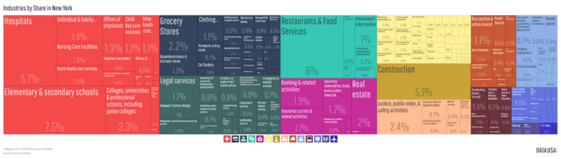
Description: A tree map showing New York State's economy by industry according to ACS PUMS 5-year estimates (2014). Percentages represent size of industry by employed population.
Title: Tree Map of Industries by Share in New York (2014)
Credit: http://datausa.io/profile/geo/new-york/#tmap_ind_num_emp
Author: Datawheel, LLC
Usage Terms: GNU Affero General Public License
License: AGPL
License Link: http://www.gnu.org/licenses/agpl.html
Attribution Required?: Yes
Image usage
The following page links to this image:

All content from Kiddle encyclopedia articles (including the article images and facts) can be freely used under Attribution-ShareAlike license, unless stated otherwise.
.png)