
Image: Trent-Severn Waterway map

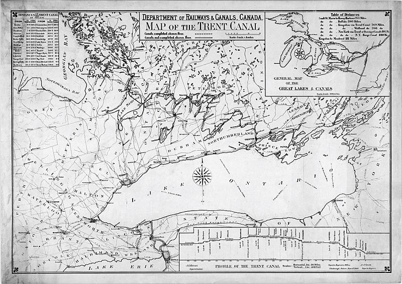
Description: A map of the Trent-Severn Waterway as it appeared in 1918. The route as it existed at that time is complete to Trenton, and shown as a heavy dashed line. The yet-to-be-completed link to Georgian Bay, at this time still planned to run through Honey Harbour rather than the ultimate route through Port Severn, is shown as a dotted line. The Newmarket Canal is also shown, at the south end of Lake Simcoe, just prior to its cancellation. The map also shows the many railways in the area, notably the Port Perry and Port Whitby that connects to Lake Scugog (just northeast of Toronto), the closest approach the Waterway makes to Toronto. The Cobourg and Rice Lake railway has already been lifted by the time this map was produced. The inset map in the upper right shows the system in relation to other canals in the area. These include the Rideau Canal, the Welland Canal, the New York Barge Canal (which had replaced the Erie Canal by this point) and its various connections, and, at the extreme north of the map, the Georgian Bay Canal which was never built.
Title: Trent-Severn Waterway map
Credit: http://data2.archives.ca/nmc/n0021816.pdf
Author: A.K. Killaly, superintendent of the (Canadian) Department of Railways and Canals
Usage Terms: Public domain
License: Public domain
Attribution Required?: No
Image usage
The following page links to this image:
