
Image: Tri-State Tornado trackmap cropped
No higher resolution available.
Tri-State_Tornado_trackmap_cropped.png (366 × 320 pixels, file size: 33 KB, MIME type: image/png)
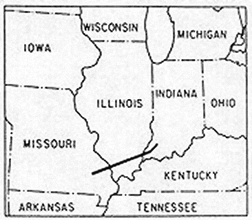
Description: A map of the track of the 219-mile, 3.5 hour Tri-State Tornado which killed 695 in Missouri, Illinois, and Indiana on 18 March 1925.
Usage Terms: Public domain
Image usage
The following page links to this image:

All content from Kiddle encyclopedia articles (including the article images and facts) can be freely used under Attribution-ShareAlike license, unless stated otherwise.