
Image: Tulunids 893

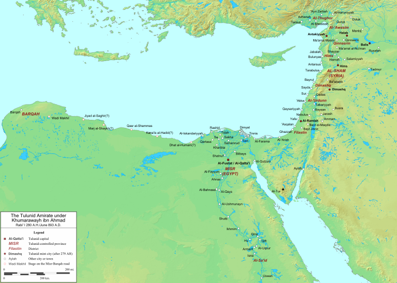
Description: Map of the Tulunid Amirate in 893 AD. This depicts the extent of the amirate after the Abbasid caliph al-Mu'tadid formally granted the Tulunid ruler Khumarawayh ibn Ahmad ibn Tulun the governorship of the lands "between al-Furat (the Euphrates) and Barqah" for thirty years. Tulunid possessions in al-Jazirah appear to have been ceded or lost at the time of this grant. See al-Kindi, p. 239; Bianquis, pp. 105-06; Haarmann, p. 49. Geographical information regarding the districts and cities of Egypt and Syria is derived from Ibn Khurradadhbih pp. 55-61, 72 (French translation), with the sole exception of the Tulunid capital of al-Qatta'i. The identity of Tulunid mint cities is derived from Shamma, p. 44. Background topography taken from DEMIS Mapserver, which are public domain. Works Cited: Bianquis, Thierry. "Autonomous Egypt from Ibn Tulun to Kafur, 868-969." The Cambridge History of Egypt, Volume One: Islamic Egypt, 640-1517. Ed. Carl F. Petry. Cambridge: Cambridge University Press, 1998. ISBN 0-521-47137-0 Haarmann, U. "Khumarawayh." The Encyclopaedia of Islam, Volume V. New Ed. Leiden: E.J. Brill, 1986. ISBN 90-04-07819-3. Ibn Khurradadhbih, Abu al-Qasim 'Abd Allah. Kitab al-Masalik wa'l-Mamalik. Ed and trans. M.J. de Goeje. Leiden: E.J. Brill, 1889. Al-Kindi, Muhammad ibn Yusuf. The Governors and Judges of Egypt. Ed. Rhuvon Guest. Leyden and London: E.J. Brill, 1912. Shamma, Samir. "The Coinage of the Tulunids in Filastin: A Short Historical Note. Al-Abhath, 24 (1971), pp. 43-49.
Title: Tulunids 893
Credit: Own work
Author: Ro4444
Usage Terms: Creative Commons Attribution-Share Alike 3.0
License: CC BY-SA 3.0
License Link: https://creativecommons.org/licenses/by-sa/3.0
Attribution Required?: Yes
Image usage
The following page links to this image:
