
Image: Upsala Glacier, Argentina

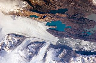
Description: The Southern Patagonian Icefield of Argentina and Chile is the southern remnant of the Patagonia Ice Sheet that covered the southern Andes Mountains during the last ice age. This detailed astronaut photograph illustrates the terminus of one of the ice-field’s many spectacular glaciers—Upsala Glacier, located on the eastern side of the ice-field. This image was taken during spring in the Southern Hemisphere, and icebergs were calving from the glacier terminus into the waters of Lago Argentino (Lake Argentina, image right). Two icebergs are especially interesting because they retain fragments of the moraine (rock debris) that forms a dark line along the upper surface of the glacier. The inclusion of the moraine illustrates how land-based rocks and sediment may wind up in ocean sediments far from shore. Moraines are formed from rock and soil debris that accumulate along the front and sides of a flowing glacier. The glacier is like a bulldozer that pushes soil and rock in front of it, leaving debris on either side. When two glaciers merge (image centre), moraines along their edges can join to form a medial moraine that is drawn out along the upper surface of the new glacier.
Title: Upsala Glacier, Argentina
Credit: NASA Earth Observatory
Author: This image was taken by the NASA Expedition 21 crew Image acquired with a Nikon D2Xs digital camera fitted with a 400 mm lens, and is provided by the ISS Crew Earth Observations experiment and Image Science & Analysis Laboratory, Johnson Space Centre.
Usage Terms: Public domain
License: Public domain
Attribution Required?: No
Image usage
The following 2 pages link to this image:
