
Image: Uryankhay-Tuva AO

Size of this preview: 800 × 498 pixels. Other resolutions: 320 × 199 pixels | 1,599 × 996 pixels.
Original image (1,599 × 996 pixels, file size: 19 KB, MIME type: image/png)
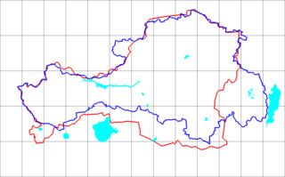
Description: Blue line is the Uriankhay (1914) border line (reconstructed using SRTM mission DEM) as upper Yenisey watershed area plus upper Us and Kantegir river valleys. Red line is the Tuva Autonomous Oblast boundary line reprojected and vectorized from the Soviet atlas (1954 issue) with boundaries as of 1953.
Title: Uryankhay-Tuva AO
Credit: Soviet atlas (1954 issue) with boundaries as of 1953 by Bogomolov.PL.
Author: Bogomolov.PL
Permission: Bogomolov.PL's map: Own work.
Usage Terms: Public domain
License: Public domain
Attribution Required?: No
Image usage
The following page links to this image:

All content from Kiddle encyclopedia articles (including the article images and facts) can be freely used under Attribution-ShareAlike license, unless stated otherwise.