
Image: Venezuela en 1810

Size of this preview: 800 × 554 pixels. Other resolutions: 320 × 222 pixels | 1,539 × 1,066 pixels.
Original image (1,539 × 1,066 pixels, file size: 683 KB, MIME type: image/jpeg)
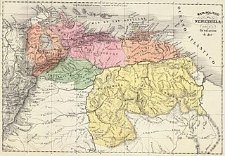
Description: Political map of Venezuela in 1810. Taken from the "Physical and Political Atlas of the Republic of Venezuela", by Agustín Codazzi, 1840.
Title: Venezuela en 1810
Credit: Historical Maps by Agustín Codazzi, from David Rumsey Website
Author: Agostino Codazzi
Usage Terms: Public domain
License: Public domain
Attribution Required?: No
Image usage
The following 2 pages link to this image:

All content from Kiddle encyclopedia articles (including the article images and facts) can be freely used under Attribution-ShareAlike license, unless stated otherwise.