
Image: Vespacians Camp Wiltshire

Size of this preview: 800 × 513 pixels. Other resolutions: 320 × 205 pixels | 911 × 584 pixels.
Original image (911 × 584 pixels, file size: 134 KB, MIME type: image/jpeg)
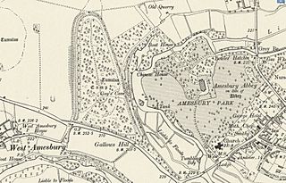
Description: Section of the six inches to the mile OS map of Wiltshire, England published in 1901. It shows the location of Vespacians Camp Iron Age hill fort in relation to West Amesbury, Amesbury Abbey and the modern town of Amesbury.
Title: Vespacians Camp Wiltshire
Credit: National Library Of Scotland map archive
Author: Ordnance Survey 1901
Usage Terms: Public domain
License: Public domain
Attribution Required?: No
Image usage
The following page links to this image:

All content from Kiddle encyclopedia articles (including the article images and facts) can be freely used under Attribution-ShareAlike license, unless stated otherwise.