
Image: Wacht am Rhein map

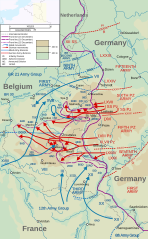
Description: Map of the opening of the salient, the start of the Battle of the Bulge (German: Wacht am Rhein, "Watch on the Rhine"). Map covers 16–25 December 1944. Map data, operation lines, etc. taken from File:P23(map).jpg, a US military source. Front lines Front line, 16 December Front line, 20 December Front line, 25 December Altitude and international borders Under 200m 200–400m Above 400m International borders Abbreviations ID: Infantry Division ABD: Airborne Division AD: Armoured Division BR: British Movements: Allied movements German movements Armies are denoted in the largest type; Corps are denoted in Roman numerals; Allied divisions are shown in the smallest type. Dashed lines denoted "XXXX" mark divisions between armies. Dashed lines denoted "XXXXX" mark divisions between army groups.
Title: Wacht am Rhein map
Credit: This file was derived from: France blank.svg: P23(map).jpg: Wacht am Rhein map-Edit1.svg: File:Wacht am Rhein map-Edit1.svg
Author: France_blank.svg: Eric Gaba (Sting - fr:Sting) P23(map).jpg: US Military w:File:Wacht am Rhein map-Edit1.svg: Matthewedwards derivative work: Grandiose (talk)
Usage Terms: Creative Commons Attribution-Share Alike 3.0
License: CC BY-SA 3.0
License Link: https://creativecommons.org/licenses/by-sa/3.0
Attribution Required?: Yes
Image usage
The following 3 pages link to this image:
