
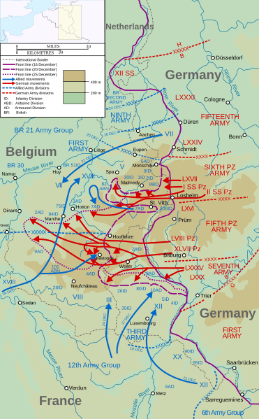
Image: Wacht am Rhein map (Opaque)

Description: English: Map of the opening of the salient, the start of the Battle of the Bulge (German: Wacht am Rhein, "Watch on the Rhine"). Map covers 16 – 25 December 1944. Main source for map is File:P23(map).jpg, taken from http://www.history.army.mil/brochures/ardennes/aral.htm The frontlines in the Monschau-Malmedy-Pruem area have been adjusted as shown in, for example, http://www.defense.gov/home/Specials/bulge/images/indexb_10a.jpg and File:Battle of the Bulge 6th.jpg.
Title: Wacht am Rhein map (Opaque)
Credit: Map data, operation lines, etc. taken from File:P23(map).jpg, a US military source. Also incorporate elements from File:France_blank.svg (User:Sting), File:Maps template-history patch-en.svg (Sting and User:Yug), File:P23(map).jpg (US Military), and File:Wacht am Rhein map.svg (User:Grandiose)
Author: User:Matthewedwards
Usage Terms: Creative Commons Attribution-Share Alike 3.0
License: CC BY-SA 3.0
License Link: http://creativecommons.org/licenses/by-sa/3.0
Attribution Required?: Yes
Image usage
The following 3 pages link to this image:

.svg)