
Image: Wiyot map with locator

Size of this PNG preview of this SVG file: 396 × 599 pixels. Other resolution: 158 × 240 pixels.
Original image (SVG file, nominally 512 × 775 pixels, file size: 192 KB)
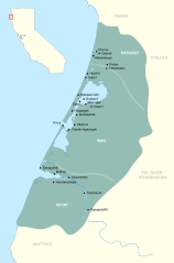
Description: Map of Wiyot dialects and villages with locator Sources: Shoreline contours from OpenStreetMap Golla, Victor; California Indian Languages (2011) [1] Loud, Llewellyn L; Ethnogeography and Archaeology of the Wiyot Territory (1918) Nomland, Gladys Ayer and Kroeber, A.L; Wiyot Towns (1936)[2]
Title: Wiyot map with locator
Credit: Own work
Author: Noahedits
Usage Terms: Creative Commons Attribution-Share Alike 4.0
License: CC BY-SA 4.0
License Link: https://creativecommons.org/licenses/by-sa/4.0
Attribution Required?: Yes
Image usage
The following page links to this image:

All content from Kiddle encyclopedia articles (including the article images and facts) can be freely used under Attribution-ShareAlike license, unless stated otherwise.