
Image: Zarit incident map
No higher resolution available.
Zarit_incident_map.png (519 × 298 pixels, file size: 67 KB, MIME type: image/png)
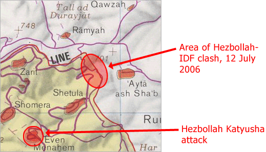
Description: Map of Zar'it and vicinity illustrating the localities involved in the Zar'it-Ayta ash-Shab incident which sparked the 2006 Israel-Lebanon conflict.
Title: Zarit incident map
Credit: Uploaded as en:Image:Zarit incident map.png. Based on http://www.lib.utexas.edu/maps/middle_east_and_asia/lebanon_southern_border_1986.jpg
Author: Original map is the work of the Central Intelligence Agency. Modifications by en:User:ChrisO.
Permission: PD
Usage Terms: Public domain
License: Public domain
Attribution Required?: No
Image usage
There are no pages that link to this image.

All content from Kiddle encyclopedia articles (including the article images and facts) can be freely used under Attribution-ShareAlike license, unless stated otherwise.