Jefferson No. 4 Precinct, Pope County, Illinois facts for kids
Quick facts for kids
Jefferson No. 4 Precinct
|
|
|---|---|

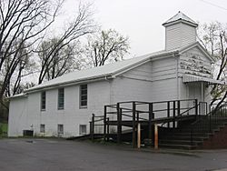
Calvary Missionary Baptist Church at New Liberty
|
|
| Country | United States |
| State | Illinois |
| County | Pope |
| Area | |
| • Total | 70.46 sq mi (182.48 km2) |
| • Land | 68.74 sq mi (178.03 km2) |
| • Water | 1.72 sq mi (4.45 km2) 2.44% |
| Elevation | 531 ft (162 m) |
| Population
(2000)
|
|
| • Total | 448 |
| • Density | 6.4/sq mi (2.46/km2) |
| GNIS feature ID | 1928546 |
Jefferson No. 4 Precinct is a small area located in Pope County, Illinois, in the USA. It's like a small neighborhood or district within the county. According to the census taken in the year 2000, about 448 people lived there.
Exploring Jefferson No. 4 Precinct's Geography
This precinct covers an area of about 182.48 square kilometers. That's roughly 70.46 square miles. Most of this area is land, with a small part made up of water. The highest point in the precinct is about 531 feet (162 meters) above sea level.
See also
 In Spanish: Distrito electoral de Jefferson n.º 4 para niños

All content from Kiddle encyclopedia articles (including the article images and facts) can be freely used under Attribution-ShareAlike license, unless stated otherwise. Cite this article:
Jefferson No. 4 Precinct, Pope County, Illinois Facts for Kids. Kiddle Encyclopedia.
