Kaspi Municipality facts for kids
Quick facts for kids
Kaspi Municipality
კასპის მუნიციპალიტეტი
|
|||
|---|---|---|---|
|
Municipality
|
|||

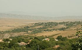
a village in Kaspi municipality
|
|||
|
|||

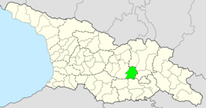
Location of Kaspi Municipality in Georgia
|
|||
| Country | |||
| Region | Shida Kartli | ||
| Capital | Kaspi | ||
| various | 1 town, 71 villages | ||
| Area | |||
| • Total | 802 km2 (310 sq mi) | ||
| Population
(2014)
|
|||
| • Total | 43,771 | ||
| • Density | 54.58/km2 (141.35/sq mi) | ||
| Time zone | UTC+4 | ||
| Website | Official site of shida kartli region: http://www.shidakartli.gov.ge/index.php?cat=77&par=6 | ||
Kaspi (Georgian: კასპის მუნიციპალიტეტი) is a special area, like a district, in the country of Georgia. It is part of the Shida Kartli region. Kaspi became a district in 1930. The main town in this district is also called Kaspi.
Contents
Exploring Kaspi's Land
This district is located in the Shida Kartli plain. It stretches along both sides of the Kura River. To the north, it touches the Greater Caucasus mountains. To the south, it borders the Trialeti Range. The Kura and Ksani are the biggest rivers flowing through Kaspi.
About 43,771 people live in the Kaspi district (as of 2014). This means there are about 55 people per square kilometer. The district has one main town and 71 villages.
The economy here mainly focuses on farming. There are also a few factories. These factories produce building materials and make wine or other alcoholic drinks.
Historical Places in Kaspi
The Kaspi district has many old and interesting historical sites. These include the Rkoni Monastery, Samtavisi Church, and Kvatakhevi Church. These places show the rich history and architecture of the area.
Ancient Discoveries: Kavtiskhevi Kurgans
Near the village of Kavtiskhevi in Kaspi Municipality, very old burial mounds called kurgans have been found. Archaeologists, led by Makharadze, dug them up in 2007.
The items found during these digs are similar to things found at other ancient sites. For example, they are like remains from the Late Chalcolithic period. This was a time when people started working with metals. One such site is Leilatepe on the Karabakh steppe. Similar kurgans have also been found at Soyuqbulaq, Agstafa.
Another important related discovery is at Berikldeebi in Kvemo Kartli. The oldest layers there are very similar. These findings show that kurgans existed in the southern Caucasus very early. They date back to the beginning of the 4th millennium BC.
See also
 In Spanish: Municipio de Kaspi para niños
Images for kids


