
National Register of Historic Places listings in Louisville's West End facts for kids
The West End of Louisville, Kentucky is a special place with many old buildings and areas that are important to history. These places are listed on the National Register of Historic Places. This is like a special list kept by the United States government to honor buildings, sites, and districts that have played a big part in American history, architecture, archaeology, engineering, or culture. When a place is on this list, it means it's recognized for its historical value and efforts are made to protect it.
In the West End of Louisville, there are 49 different places on this list. They are found in several neighborhoods:
- Algonquin
- California
- Chickasaw
- Park Hill
- Parkland
- Russell
- Shawnee
These historic sites help us learn about the past and understand how Louisville grew and changed over time.
Exploring Historic Places in West End Louisville
The West End of Louisville is home to many fascinating historic sites. These places tell stories about the people who lived and worked here, and the important events that shaped the community. Let's look at some of these special locations.
Historic Buildings: Schools, Churches, and More
Many buildings in the West End are recognized for their history. These include old schools, churches, and even industrial buildings that were once busy factories.
Schools with a Story
Schools are often at the heart of a community, and several in the West End have a rich history.
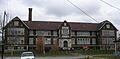
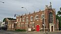
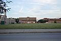
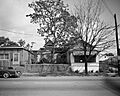
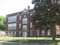
- The Albert S. Brandeis Elementary School at 1001 S. 26th St. in California was listed in 1980. It has served generations of students.
- Columbian School at 1337 Dixie Hwy. in Park Hill was added to the list in 1983. Today, it has been changed into apartments, showing how old buildings can find new uses.
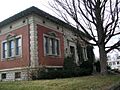
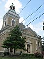
- Stephen Foster Elementary School on Garland Ave. in Chickasaw was recognized in 2006.
- Parkland Junior High School at 2509 Wilson Ave. in Parkland became historic in 1983.
- Both Shawnee Elementary School and Shawnee High School (now called The Academy @ Shawnee) on Herman St. in Shawnee were added in 1984. These schools have been important learning centers for many years.
- The Virginia Avenue Colored School at 3628 Virginia Ave. in Chickasaw was listed in 2004. This school played a vital role in the education of African American children during a time of segregation.
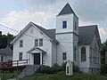
Churches: Places of Worship and Community
Churches are often central to a neighborhood's history and culture.
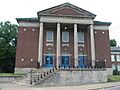
- The Broadway Temple A.M.E. Zion Church at 662 S. 13th St. in Russell was listed in 1980.
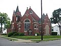
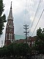
- The Chestnut Street Baptist Church at 912 W. Chestnut St., also in Russell, was added in 1980.
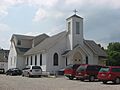
- Christ the King School and Church at 718-724 S. 44th St. in Shawnee became historic in 1983.
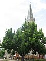
- The Church of Our Merciful Saviour at 473 S. 11th St. in Russell was listed in 1983.
- Dumesnil Street Methodist Church at 1707 Dumesnil St. in Park Hill was recognized in 1983.
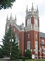
- Holy Cross Catholic Church, School and Rectory at 3112 W. Broadway in Russell was added in 1983.
- Parkland Evangelical Church at 1102 S. 26th St. in Parkland was listed in 1983.
- St. Anthony's Roman Catholic Church, Rectory, Convent, and School at 2222-2233 W. Market St. in Russell became historic in 1982.
- The St. Columba Catholic Campus at 3514 W. Market in Shawnee was listed in 2005.
- St. George's Roman Catholic Church at 1809 Standard Ave. in Park Hill was recognized in 1982.
- St. Peter's German Evangelical Church at 1231 W. Jefferson St. in Russell was added in 1980.
Industrial and Commercial Landmarks
Many buildings in the West End were once busy places of work, showing Louisville's industrial past.
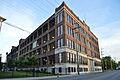
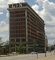
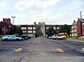
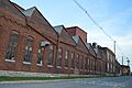
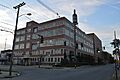
- The B.F. Avery and Sons Industrial District at 1721-1821 7th St. in Algonquin was listed in 1990. This area was once home to a large company that made farm equipment.
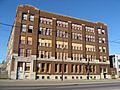
- The Axton-Fisher Tobacco Company Warehouse at 1405 W. Broadway in Russell became historic in 2003.
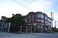
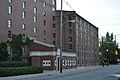
- The Bernheim Distillery Bottling Plant at 822-828 S. 15th St. in California was recognized in 1983. This building was part of a distillery, which is a place where alcoholic drinks are made.
- The Brass Finishing Building, Standard Sanitary Manufacturing Company at 1547 S. 7th St. in Algonquin was listed in 2005.
- The West End Ford Motor Plant at 1400 Southwestern Parkway was added in 1983. This was an important factory for making cars.
- The Mengel Box Company at 1247-1299 S. 12th St. in Park Hill was recognized in 1983. This company made boxes and other wood products.
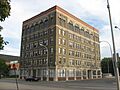
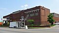
- The J.J. Reilly Manufacturing Building at 1234 Rowan St. was listed in 2019.
- The Henry Vogt Machine Company Shop at 1000 W. Ormsby Ave. in Park Hill became historic in 1982.
- Warehouse A, Brown-Forman Corporation at 1809 Garland Ave. in California was added in 1990.
- The White Mills Distillery Company at 850 Dixie Hwy. in California was listed in 1978.
- The Whiteside Bakery at 1400 W. Broadway St. in California was recognized in 1979.
Other Important Buildings
Other buildings that have played a role in the community's past include:
- The Louisville Fire Department Headquarters at 1135 W. Jefferson St. in Russell, listed in 1981.
- Hook and Ladder Company No. 4 at 2301 Jefferson St. in Russell, listed in 1980.
- Hook and Ladder Company No. 5 at 1824 Garland Ave. in California, listed in 1980.
- The Jefferson Branch Louisville Free Public Library at 1718 W. Jefferson St. in Russell, listed in 1979.
- The Knights of Pythias Temple at 928-932 W. Chestnut St. in Russell, listed in 1978. This building was used by a fraternal organization.
- The Louisville and Nashville Railroad Office Building at 908 W. Broadway in California, listed in 1983. This was an important building for the railroad.
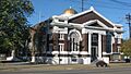
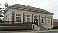
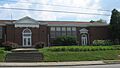
- The Louisville Free Public Library, Western Colored Branch at 604 S. 10th St. in Russell, listed in 1975. This was a very important library for the African American community, especially during times of segregation.
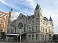
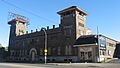
- Union Station at 1000 W. Broadway in California, listed in 1975. This was once a busy train station.
- The Universal Car Company at 2500 W. Broadway in California, listed in 2001.
Historic Homes and Districts
Many individual homes and even whole areas (called historic districts) in the West End are recognized for their unique architecture and history.
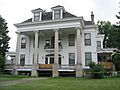
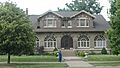
- The Anton Diebold House at 4303 W. Broadway in Shawnee was listed in 1983.
- The J.W. Diebold, Jr. House at 4119 W. Broadway in Shawnee was also listed in 1983.
- The Basil Doerhoefer House at 4432 W. Broadway in Shawnee was recognized in 1983.
- The Peter C. Doerhoefer House at 4422 W. Broadway in Shawnee was listed in 1983.
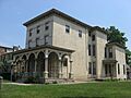
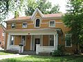
- The Doerhoefer–Hampton House at 2422 W. Chestnut St. in Russell was added in 1979.
- The F.M. Tiller House at 4309 W. Broadway in Shawnee was listed in 1983.
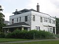
- The Wedekind House and Servant's Quarters at 2630 and 2532 W. Burnett St. in Park Hill was recognized in 1983.
Historic Districts: Whole Neighborhoods with History
Sometimes, not just one building, but a whole area is important. These are called historic districts.
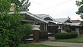
- The Marlow Place Bungalows District at 3139 to 3209 W. Broadway in Russell was listed in 1983. This district includes many bungalow-style homes.
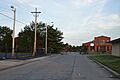
- The Parkland Historic District in Parkland, roughly bounded by railroad tracks, Hale Ave., and S. 26th and S. 30th Sts., was added in 1980.
- The Russell Historic District in Russell, roughly bounded by S. 15th, S. 26th, Congress, and W. Broadway Sts., was listed in 1980.
These historic places help us remember and appreciate the rich past of the West End of Louisville. They are important parts of our shared heritage.
Images for kids
-
B.F. Avery and Sons Industrial District
-
Axton-Fisher Tobacco Company Warehouse
-
Bernheim Distillery Bottling Plant
-
Albert S. Brandeis Elementary School
-
Brass Finishing Building, Standard Sanitary Manufacturing Company
-
Broadway Temple A.M.E. Zion Church
-
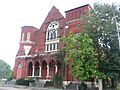
Chestnut Street Baptist Church
-
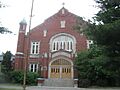
Christ the King School and Church
-
Church of Our Merciful Saviour
-
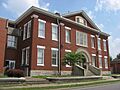
Columbian School
-
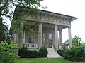
Anton Diebold House
-
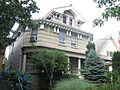
J.W. Diebold, Jr. House
-
Basil Doerhoefer House
-
Peter C. Doerhoefer House
-
Doerhoefer–Hampton House
-
Dumesnil Street Methodist Church
-
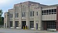
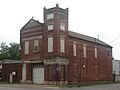
Louisville Fire Department Headquarters
-
West End Ford Motor Plant
-
Stephen Foster Elementary School
-
Holy Cross Catholic Church, School and Rectory
-
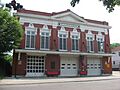
Hook and Ladder Company No. 4
-
Hook and Ladder Company No. 5
-
Jefferson Branch Louisville Free Public Library
-
Knights of Pythias Temple
-
Louisville and Nashville Railroad Office Building
-
Louisville Free Public Library, Western Colored Branch
-
Marlow Place Bungalows District
-
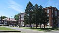
J.B. McFerran School
-
Mengel Box Company
-
Parkland Evangelical Church
-
Parkland Historic District
-
Parkland Junior High School
-
Russell Historic District
-
St. Anthony's Roman Catholic Church, Rectory, Convent, and School
-
St. Columba Catholic Campus
-
St. George's Roman Catholic Church
-
St. Peter's German Evangelical Church
-
Shawnee Elementary School
-
Shawnee High School
-
F.M. Tiller House
-
Union Station
-
Universal Car Company
-
Virginia Avenue Colored School
-
Henry Vogt Machine Company Shop
-
Warehouse A, Brown-Forman Corporation
-
Wedekind House and Servant's Quarters
-
White Mills Distillery Company
-
Whiteside Bakery


