San Cristóbal Amatlán facts for kids
Quick facts for kids
San Cristóbal Amatlán
|
|
|---|---|
|
Municipality and town
|
|
| Country | |
| State | Oaxaca |
| Area | |
| • Total | 96.96 km2 (37.44 sq mi) |
| Elevation | 1,700 m (5,590 ft) |
| Population
(2005)
|
|
| • Total | 3,978 |
| Time zone | UTC-6 (Central Standard Time) |
| • Summer (DST) | UTC-5 (Central Daylight Time) |
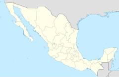
San Cristóbal Amatlán is a town and a special area called a municipality in Oaxaca, a state in southwestern Mexico. A municipality is like a local government area, similar to a county or district. This municipality covers about 96.96 square kilometers (about 37 square miles).
It is part of the Miahuatlán District, which is in the southern part of the Sierra Sur Region.
People and Language
In 2005, about 3,978 people lived in the San Cristóbal Amatlán municipality.
Many people in the town speak a language called Amatlán Zapotec. They also often speak Spanish, so they are bilingual! The town is special because it sits right at the bottom of a very tall mountain. This mountain is known as Yiroos in the Zapotec language.
Black History Month on Kiddle
Famous African-American Inventors:
 | Shirley Ann Jackson |
 | Garett Morgan |
 | J. Ernest Wilkins Jr. |
 | Elijah McCoy |

All content from Kiddle encyclopedia articles (including the article images and facts) can be freely used under Attribution-ShareAlike license, unless stated otherwise. Cite this article:
San Cristóbal Amatlán Facts for Kids. Kiddle Encyclopedia.

