San Marcos, El Salvador facts for kids
Quick facts for kids
San Marcos
|
|
|---|---|
|
Municipality
|
|

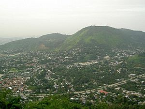
San Marcos seen from Los Planes de Renderos Hill
|
|
| Country | |
| Department | San Salvador Department |
| Area | |
| • Municipality | 5.7 sq mi (14.7 km2) |
| Elevation | 2,608 ft (795 m) |
| Population
(2020)
|
|
| • Municipality | 74,221 |
| • Urban | 74,221 |
San Marcos is a town in El Salvador. It sits in a small valley. This town is about 5 miles (8 km) southeast of downtown San Salvador. In 2020, about 74,221 people lived there. San Marcos is part of the larger Metropolitan Area of San Salvador. This area is also known as Greater San Salvador.
Exploring San Marcos Geography
The town of San Marcos has many small hills. It is also close to two important mountains. To the north is Mount San Jacinto. To the south are the Planes de Renderos hills.
Most of San Marcos is a place where people live. You can find many homes for middle-income and low-income families here. The town is also a key entry point for people arriving by plane. This is because the Comalapa Highway runs along its border. This highway connects El Salvador International Airport to San Salvador.
San Marcos Economy
San Marcos has a public market where people buy and sell goods. There is also a bus station for buses going southeast. The town is home to a notable textile industry. This industry is located in the San Marcos Free Trade Zone.
You can also find logistics and distribution companies along the Comalapa Highway. These companies help move goods around. In 2002, the average income per person in San Marcos was about US $5,480. The town also had a Human Development Index of 0.759, which measures how well people are living.
See also
 In Spanish: San Marcos (El Salvador) para niños


