Xochihuehuetlán facts for kids
Quick facts for kids
Xochihuehuetlán
|
|
|---|---|
|
Municipal seat and city
|
|
| Country | |
| State | Guerrero |
| Municipality | Xochihuehuetlán |
| Time zone | UTC-6 (Zona Centro) |
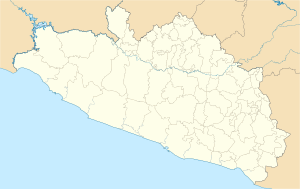
Xochihuehuetlán is a city in the southern Mexican state of Guerrero. It is also the main town of the municipality of Xochihuehuetlán. This means it's the central place for the local government.
Contents
Exploring Xochihuehuetlán's Location
Xochihuehuetlán is found in the state of Guerrero, Mexico. This state is in the southern part of the country. Knowing its location helps us understand its climate.
What is the Climate Like in Xochihuehuetlán?
The climate in Xochihuehuetlán is generally warm. It has hot summers and mild winters. The temperature can get quite high, especially in May.
Understanding the Weather Data
The weather information below shows average temperatures and rainfall. It covers data from 1951 to 2010. This helps us see the usual weather patterns.
- Hottest Months: April and May often have the highest temperatures. They can reach over 37°C (98°F).
- Coolest Months: December and January are the coolest. Average lows are around 10°C (50°F).
- Rainy Season: Most rain falls from June to September. This is when the area gets the most precipitation.
- Dry Season: The months from November to March are much drier. There is very little rain during this time.
| Climate data for Xochihuehuetlán (1951–2010) | |||||||||||||
|---|---|---|---|---|---|---|---|---|---|---|---|---|---|
| Month | Jan | Feb | Mar | Apr | May | Jun | Jul | Aug | Sep | Oct | Nov | Dec | Year |
| Record high °C (°F) | 36.0 (96.8) |
38.0 (100.4) |
42.0 (107.6) |
42.0 (107.6) |
43.0 (109.4) |
42.0 (107.6) |
41.0 (105.8) |
43.0 (109.4) |
42.0 (107.6) |
37.0 (98.6) |
37.0 (98.6) |
36.0 (96.8) |
43.0 (109.4) |
| Mean daily maximum °C (°F) | 31.3 (88.3) |
33.1 (91.6) |
35.6 (96.1) |
37.6 (99.7) |
37.1 (98.8) |
34.3 (93.7) |
32.8 (91.0) |
33.1 (91.6) |
32.3 (90.1) |
32.1 (89.8) |
32.1 (89.8) |
31.4 (88.5) |
33.6 (92.5) |
| Daily mean °C (°F) | 20.8 (69.4) |
22.6 (72.7) |
24.8 (76.6) |
27.3 (81.1) |
27.9 (82.2) |
26.7 (80.1) |
25.4 (77.7) |
25.5 (77.9) |
25.2 (77.4) |
24.0 (75.2) |
22.2 (72.0) |
20.8 (69.4) |
24.4 (75.9) |
| Mean daily minimum °C (°F) | 10.3 (50.5) |
12.0 (53.6) |
14.1 (57.4) |
16.9 (62.4) |
18.6 (65.5) |
19.1 (66.4) |
17.9 (64.2) |
17.9 (64.2) |
18.1 (64.6) |
15.9 (60.6) |
12.3 (54.1) |
10.3 (50.5) |
15.3 (59.5) |
| Record low °C (°F) | 1.0 (33.8) |
4.5 (40.1) |
4.0 (39.2) |
11.0 (51.8) |
13.5 (56.3) |
14.0 (57.2) |
11.0 (51.8) |
11.5 (52.7) |
12.0 (53.6) |
4.0 (39.2) |
3.0 (37.4) |
2.0 (35.6) |
1.0 (33.8) |
| Average precipitation mm (inches) | 5.4 (0.21) |
3.9 (0.15) |
4.4 (0.17) |
15.6 (0.61) |
70.5 (2.78) |
162.7 (6.41) |
129.1 (5.08) |
153.2 (6.03) |
149.6 (5.89) |
53.0 (2.09) |
7.9 (0.31) |
3.9 (0.15) |
759.2 (29.89) |
| Average precipitation days (≥ 0.1 mm) | 0.9 | 0.6 | 0.7 | 1.9 | 6.4 | 13.9 | 13.5 | 13.5 | 13.3 | 5.4 | 0.9 | 0.5 | 71.5 |
| Source: Servicio Meteorologico Nacional | |||||||||||||
See also
 In Spanish: Xochihuehuetlán para niños

All content from Kiddle encyclopedia articles (including the article images and facts) can be freely used under Attribution-ShareAlike license, unless stated otherwise. Cite this article:
Xochihuehuetlán Facts for Kids. Kiddle Encyclopedia.


