
Forsyth County, Georgia facts for kids
Quick facts for kids
Forsyth County
|
|
|---|---|

Forsyth County Courthouse in Cumming
|
|

Location within the U.S. state of Georgia
|
|
 Georgia's location within the U.S. |
|
| Country | |
| State | |
| Founded | December 3, 1831 |
| Named for | John Forsyth |
| Seat | Cumming |
| Largest city | Cumming |
| Area | |
| • Total | 247 sq mi (640 km2) |
| • Land | 224 sq mi (580 km2) |
| • Water | 23 sq mi (60 km2) 9.4%% |
| Population
(2020)
|
|
| • Total | 251,283 |
| • Density | 1,090/sq mi (420/km2) |
| Time zone | UTC−5 (Eastern) |
| • Summer (DST) | UTC−4 (EDT) |
| Congressional districts | 7th, 9th |
Forsyth County ( FOR-sythe or FOR-sythe) is a county in the north-central portion of the U.S. state of Georgia. Suburban and exurban in character, Forsyth County lies within the Atlanta Metropolitan Area. The county's only incorporated city and county seat is Cumming. As of 2019 estimates, the population was 244,252. Forsyth was the fastest-growing county in Georgia and the 15th fastest-growing county in the United States between 2010 and 2019.
Forsyth County's rapid population growth can be attributed to its proximity to high-income employment opportunities in nearby Alpharetta and northern Fulton County, its equidistant location between the big-city amenities of bustling Atlanta and the recreation offerings of the scenic Blue Ridge Mountains, its plentiful supply of large, relatively affordable new-construction homes, and its highly ranked public school system. The influx of high-income professionals and their families has increased the county's median annual household income dramatically in recent years; at $104,687, Forsyth County was the wealthiest in Georgia and the 19th-wealthiest in the United States as of 2018 estimates.
In the 1980s, the county attracted national media attention as the site of large civil rights demonstrations and counter-demonstrations. Organizers hoped to dispel the county's image as a conservative and hate-filled sundown town; African Americans were unjustly forced out in 1912 and the county had a reputation of being hostile to people of color and LGBT people for many decades since. Thousands of marchers on both sides came from outside the area; officials kept peace with police officers and National Guard protecting the event.
From 2007 to 2009, the county received national attention because of a severe drought. Water supplies for the Atlanta area and downstream areas of Alabama and Florida were threatened. This followed a more severe drought in 2007 and 2008, and flooding in 2009. Flooding occurred in 2013, and severe drought again in 2016. Georgia, Alabama and Florida have been in a tri-state water dispute since 1990 over apportionment of water flow from Lake Lanier, which forms the eastern border of the county and is regulated by the Army Corps of Engineers as a federal project.
Contents
History
For thousands of years, varying indigenous cultures lived in this area along the Etowah River. Starting near the end of the first millennium, Mound Builders of the Mississippian culture settled in this area; they built earthwork mound structures at nearby Etowah in present-day Bartow County, and large communities along the Etowah River in neighboring Cherokee County. They disappeared about 1500CE, before European encounter.
Members of the Iroquoian-speaking Cherokee Nation migrated into the area from the North, possibly from the Great Lakes area. They settled in the territory that would become Forsyth County and throughout upper Georgia and Alabama, also having settlements or towns in present-day Tennessee and western North Carolina.
After the discovery of gold by European Americans in the surrounding area in 1829, numerous settlers moved into the area. They increased the pressure on the state and federal government to have the Cherokee and other Native Americans removed to west of the Mississippi River, in order to extinguish their land claims and make land available for purchase. The Cherokee were forced to relocate during what was called the Trail of Tears.
Forsyth County was named after John Forsyth, Governor of Georgia from 1827–1829 and Secretary of State under Presidents Andrew Jackson and Martin Van Buren. For many years, much of this hill country was farmed by yeomen farmers, who did not own many slaves.
Geography
According to the U.S. Census Bureau, the county has a total area of 247 square miles (640 km2), of which 224 square miles (580 km2) is land and 23 square miles (60 km2) (9.4%) is water.
The eastern two-thirds of Forsyth County are located in the Upper Chattahoochee River sub-basin of the ACF River Basin (Apalachicola-Chattahoochee-Flint River Basin), while the northwestern third of the county is located in the Etowah River sub-basin of the ACT River Basin (Coosa-Tallapoosa River Basin).
Major highways
 U.S. Route 19
 State Route 9
 State Route 20
 State Route 53
 State Route 141
 State Route 306
 State Route 369
 State Route 371
 State Route 400
Adjacent counties
- Dawson County - north
- Hall County - east
- Gwinnett County - southeast
- Fulton County - southwest
- Cherokee County - northwest
National protected areas
Demographics
| Historical population | |||
|---|---|---|---|
| Census | Pop. | %± | |
| 1840 | 6,619 | — | |
| 1850 | 8,850 | 33.7% | |
| 1860 | 7,749 | −12.4% | |
| 1870 | 7,983 | 3.0% | |
| 1880 | 10,559 | 32.3% | |
| 1890 | 11,155 | 5.6% | |
| 1900 | 11,550 | 3.5% | |
| 1910 | 11,940 | 3.4% | |
| 1920 | 11,755 | −1.5% | |
| 1930 | 10,624 | −9.6% | |
| 1940 | 11,322 | 6.6% | |
| 1950 | 11,005 | −2.8% | |
| 1960 | 12,170 | 10.6% | |
| 1970 | 16,928 | 39.1% | |
| 1980 | 27,958 | 65.2% | |
| 1990 | 44,083 | 57.7% | |
| 2000 | 98,407 | 123.2% | |
| 2010 | 175,511 | 78.4% | |
| 2020 | 251,283 | 43.2% | |
| U.S. Decennial Census 1790-1960 1900-1990 1990-2000 2010-2019 |
|||
2019 ACS Estimates
| Population | ||
|---|---|---|
| Group | Estimate | Percent |
| Total Population | 244,252 | |
| Population by Sex | ||
| Group | Estimate | Percent |
| Male | 121,237 | 49.6% |
| Female | 123,015 | 50.4% |
| Sex ratio (males per 100 females) | 98.6 | |
| Population by Age | ||
| Group | Estimate | Percent |
| Under 5 years | 13,994 | 5.7% |
| 5 to 9 years | 18,347 | 7.5% |
| 10 to 14 years | 20,921 | 8.6% |
| 15 to 19 years | 18,940 | 7.8% |
| 20 to 24 years | 11,754 | 4.8% |
| 25 to 29 years | 9,959 | 4.1% |
| 30 to 34 years | 12,587 | 5.2% |
| 35 to 39 years | 20,384 | 8.3% |
| 40 to 44 years | 19,561 | 8.0% |
| 45 to 49 years | 21,707 | 8.9% |
| 50 to 54 years | 18,460 | 7.6% |
| 55 to 59 years | 15,368 | 6.3% |
| 60 to 64 years | 11,795 | 4.8% |
| 65 to 69 years | 10,708 | 4.4% |
| 70 to 74 years | 7,571 | 3.1% |
| 75 to 79 years | 6,607 | 2.7% |
| 80 to 84 years | 3,552 | 1.5% |
| 85 years and over | 2,037 | 0.8% |
| Median age (years) | 38.8 | |
| Population by Race and Ethnicity | ||
| Group | Estimate | Percent |
| White | 182,582 | 74.8% |
| --- White, not Hispanic or Latino | 167,871 | 68.7% |
| Asian | 35,925 | 14.7% |
| --- Asian Indian | 26,220 | 10.7% |
| Hispanic or Latino (of any race) | 23,606 | 9.7% |
| --- Mexican | 13,758 | 5.6% |
| Black or African American | 9,585 | 3.9% |
| Some other race | 7,860 | 3.2% |
| Two or more races | 5,013 | 2.1% |
| American Indian or Alaska Native | 2,330 | 1.0% |
| Native Hawaiian and Pacific Islander | 0 | 0.0% |
| Population by Nativity and Citizenship Status | ||
| Group | Estimate | Percent |
| Native (born in the United States) | 199,623 | 81.7% |
| --- Born in Georgia | 96,474 | 39.5% |
| --- Born in other U.S. state | 99,431 | 40.7% |
| ------ Southern state | 40,445 | 16.6% |
| ------ Midwestern state | 24,788 | 10.1% |
| ------ Northeastern state | 24,091 | 9.9% |
| ------ Western state | 10,107 | 4.1% |
| --- Native born outside U.S. states | 3,718 | 1.5% |
| Foreign Born | 44,629 | 18.3% |
| --- Not a U.S. citizen | 25,634 | 10.5% |
| --- Naturalized U.S. citizen | 18,995 | 7.8% |
2010 Census
As of the 2010 United States Census, there were 175,511 people, 59,433 households, and 47,623 families residing in the county. The population density was 783.5 inhabitants per square mile (302.5/km2). There were 64,052 housing units at an average density of 285.9 per square mile (110.4/km2). The racial makeup of the county was 85.4% white, 6.2% Asian, 2.6% black or African American, 0.3% American Indian, 3.8% from other races, and 1.6% from two or more races. Those of Hispanic or Latino origin made up 9.4% of the population. In terms of ancestry, 15.7% were German, 14.4% were American, 14.2% were Irish, 12.9% were English, and 5.8% were Italian.
Of the 59,433 households, 46.9% had children under the age of 18 living with them, 68.5% were married couples living together, 8.0% had a female householder with no husband present, 19.9% were non-families, and 15.9% of all households were made up of individuals. The average household size was 2.94 and the average family size was 3.29. The median age was 36.9 years.
The median income for a household in the county was $87,605 and the median income for a family was $96,501. Males had a median income of $72,030 versus $46,310 for females. The per capita income for the county was $35,385. About 4.5% of families and 6.0% of the population were below the poverty line, including 7.0% of those under age 18 and 4.9% of those age 65 or over.
2020 census
The 2020 United States Census indicated that the county gained 43% in its population in the preceding decade. This was the largest percentage increase of any county in the state.
| Race | Num. | Perc. |
|---|---|---|
| White (non-Hispanic) | 159,407 | 63.44% |
| Black or African American (non-Hispanic) | 10,455 | 4.16% |
| Native American | 456 | 0.18% |
| Asian | 45,117 | 17.95% |
| Pacific Islander | 85 | 0.03% |
| Other/Mixed | 10,537 | 4.19% |
| Hispanic or Latino | 25,226 | 10.04% |
As of the 2020 United States census, there were 251,283 people, 81,765 households, and 66,802 families residing in the county.
Life expectancy
The life expectancy in Forsyth County in 2014 was 81.28 years, up 10.98 percent from 73.24 years in 1980. By comparison, the U.S. national average in 2014 was 78.91 years.
Recreation

Lake Lanier, a 37,000-acre (150 km2) lake created and maintained by the United States Army Corps of Engineers in association with Buford Dam, is enjoyed by many residents and non-residents alike. Fishing, boating, tubing, wake boarding, and water skiing are common activities on the lake.
Forsyth County Parks and Recreation Department maintains more than 15 parks in the county. Most notable are Sawnee Mountain Preserve, Central Park, Fowler Park, Poole's Mill Covered Bridge and the Big Creek Greenway. The Cumming Fairgrounds host many events throughout the year including a rodeo, The Cumming Country Fair, and a farmers' market. There is also the annual 4 July Steam Engine Parade.
Communities
City
Unincorporated communities
With only one officially incorporated city, the majority of Forsyth County citizens live in areas with zip codes assigned to cities in surrounding counties.
- Alpharetta - 30005, 30004
- Ball Ground - 30107
- Cumming - 30041, 30040, 30028
- Duluth - 30097
- Gainesville - 30506
- Suwanee - 30024
In addition, there are several unincorporated communities throughout the county.
- Brookwood
- Coal Mountain
- Chestatee
- Silver City
- Daves Creek
- Friendship
- Oscarville
- Big Creek
- Matt
- Ducktown
Economy
Among the largest employers in the county are Northside Hospital, Koch Foods, Tyson Foods, Siemens, Scientific Games Corporation, Arris International, Baran Telecom, America BOA, Automation Direct, and L-3 Communications Display Systems.
An indicator that part of the county had reached the status of a mainstream suburban/exurban area and was starting to create new, positive history beyond its racist past, a mixed-use development Halcyon with residential, office, dining and entertainment facilities, opened in the southern part of the county near Alpharetta in summer 2019.
Education
Higher education
In 2012, the University of North Georgia established its Cumming campus.
Private K-12 education
- Cornerstone Schools
- Covenant Christian Academy
- Fideles Christian School
- Friendship Christian School
- Horizon Christian Academy
- Ivy League Montessori School
- Lakeview Academy
- McGinnis Woods Country Day School
- Montessori Academy at Sharon Springs
- Pinecrest Academy
Public K-12 education
Forsyth County is served by Forsyth County Schools. FCS serves over 51,000 students and is the largest employer in the county with over 8000 full-time employees and substitutes. Out of 180 school districts, FCS is the seventh largest school system in Georgia. FCS is home to 41 schools – twenty-two elementary, eleven middle, seven high schools, and one college and career high school, as well as the Academies for Creative Education (A.C.E) that houses one school, iAchieve Virtual Academy, FCS' 6–12 online school, and two programs, Gateway Academy (the alternative program for middle and high school students) and Forsyth Academy.
Elementary schools:
- Big Creek Elementary School
- Brandywine Elementary School
- Brookwood Elementary School
- Chattahoochee Elementary School
- Chestatee Elementary School
- Coal Mountain Elementary School
- Cumming Elementary School
- Daves Creek Elementary School
- Haw Creek Elementary School
- Johns Creek Elementary School
- Kelly Mill Elementary School
- Mashburn Elementary School
- Matt Elementary School
- Midway Elementary School
- Poole's Mill Elementary School
- Sawnee Elementary School
- Settles Bridge Elementary School
- Sharon Elementary School
- Shiloh Point Elementary School
- Silver City Elementary School
- Vickery Creek Elementary School
- Whitlow Elementary School.
Middle schools:
- DeSana Middle School
- Hendricks Middle School
- Lakeside Middle School
- Liberty Middle School
- Little Mill Middle School
- North Forsyth Middle School
- Otwell Middle School
- Piney Grove Middle School
- Riverwatch Middle School
- South Forsyth Middle School
- Vickery Creek Middle School.
High schools:
- Alliance Academy for Innovation
- Denmark High School
- East Forsyth High School
- Forsyth Central High School
- Lambert High School
- North Forsyth High School
- South Forsyth High School
- West Forsyth High School.
Transportation
Major highways
- U.S. Route 19 (Lee Highway)
- State Route 9
- State Route 20
- State Route 53
- State Route 141
- State Route 306
- State Route 369
- State Route 371
- State Route 400
Pedestrians and cycling
- Big Creek Greenway
Images for kids
-
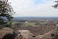
View of northern Forsyth County from Sawnee Mountain's Indian Seats

See also
 In Spanish: Condado de Forsyth (Georgia) para niños
