
Tropical cyclone facts for kids


A tropical cyclone is a circular air movement that starts over the warm ocean waters in the warm part of Earth near the Equator. Most tropical cyclones create fast winds and great rains. While some tropical cyclones stay out in the sea, others pass over land. They can be dangerous because of flooding and because the winds pick up objects, including things as big as small boats. Tropical cyclones can throw these things at high speeds.
Tropical cyclones, hurricanes or typhoons form when convection causes warm, moist air above the ocean to rise. They begin as a group of storms when the water gets as hot as 80 °F (27 °C) or hotter. The Coriolis effect made by the Earth's rotation causes the winds to rotate. Warm air rises quickly. Tropical cyclones usually move westward in the tropics, and can later move north or south into the temperate zone. The "eye of the storm" is the center. It has little rain or wind. The eye wall has the heaviest rain and the fastest winds. It is surrounded by rain bands which also have fast winds.
Tropical cyclones are powered by warm, humid ocean air. When they go onto land, they weaken. They die when they spend a long time over land or cool ocean water.
Contents
Naming
Tropical cyclones are usually given names because it helps in forecasting, locating, and reporting. They are named once they have steady winds of 62 km/h. Committees of the World Meteorological Organization pick names. Once named, a cyclone is usually not renamed.
For several hundred years hurricanes were named after saints. In 1887, Australian meteorologist Clement Wragge began giving women's names to tropical cyclones. He thought of history and mythology for names. When he used men's names, they were usually of politicians he hated. By World War II cyclone names were based on the phonetic alphabet (Able, Baker, Charlie). In 1953 the United States stopped using phonetic names and began using female names for these storms. This ended in 1978 when both male and female names were used for Pacific storms. In 1979 this practice was added for hurricanes in the Gulf of Mexico and the Atlantic.
Classifications
| Category | Wind speeds |
|---|---|
| Five | ≥70 m/s, ≥137 knots ≥157 mph, ≥252 km/h |
| Four | 58–70 m/s, 113–136 knots 130–156 mph, 209–251 km/h |
| Three | 50–58 m/s, 96–112 knots 111–129 mph, 178–208 km/h |
| Two | 43–49 m/s, 83–95 knots 96–110 mph, 154–177 km/h |
| One | 33–42 m/s, 64–82 knots 74–95 mph, 119–153 km/h |
| Tropical storm |
18–32 m/s, 34–63 knots 39–73 mph, 63–118 km/h |
|---|---|
| Tropical depression |
≤17 m/s, ≤33 knots ≤38 mph, ≤62 km/h |
Tropical cyclones are classified into different categories by their strength and location. The National Hurricane Center, which observes hurricanes in the Atlantic Ocean and Eastern and Central Pacific Ocean, classifies them using the Saffir-Simpson Hurricane Scale.
Tropical cyclones in other places such as the Western Pacific Ocean or the Southern Hemisphere are classified on scales that are quite a bit like the Saffir-Simpson Scale. For example; if a tropical storm in the western Pacific reaches hurricane-strength winds, it is then officially called a typhoon.
A tropical depression is an organized group of clouds and thunderstorms with a clear circulation in air near the ocean and maximum continuing winds of less than 17 m/s (33 kt, 38 mph, or 62 km/h). It has no eye and does not usually have the spiral shape that more powerful storms have. Only the Philippines are known to name tropical depressions.
A tropical storm is an organized system of strong thunderstorms with a very clear surface circulation and continuing winds between 17 and 32 m/s (34–63 kt, 39–73 mph, or 62–117 km/h). At this point, the cyclonic shape starts to form, although an eye does not usually appear in tropical storms. Most tropical cyclone agencies start naming cyclonic storms at this level, except for the Philippines which have their own way of naming cyclones.
A hurricane or typhoon or a cyclone is a large cyclonic weather system with continuing winds of at least 33 m/s (64 kt, 74 mph, or 118 km/h). A tropical cyclone with this wind speed usually develops an eye, which is an area of calm conditions at the center of its circulation. The eye is often seen from space as a small, round, cloud-free spot. Around the eye is the eye wall, an area where the strongest thunderstorms and winds spin around the storm's center. The fastest possible continuing wind speed found in tropical cyclones is thought to be around 85 m/s (165 kt, 190 mph, 305 km/h).
Tropical cyclone, typhoon or hurricane
The term "tropical cyclone" is a summary term. In various places tropical cyclones have other local names such as "hurricane" and "typhoon". A tropical cyclone that forms in the Atlantic Ocean is called a hurricane. The word hurricane is also used for those that form in the eastern, central and northern Pacific. In the western Pacific a tropical cyclone is called a typhoon. In the Indian Ocean it is called a "cyclone".
Formation

Tropical cyclones tend to develop during the summer, but have been noted in nearly every month in most tropical cyclone basins. Tropical cyclones on either side of the Equator generally have their origins in the Intertropical Convergence Zone, where winds blow from either the northeast or southeast. Within this broad area of low-pressure, air is heated over the warm tropical ocean and rises in discrete parcels, which causes thundery showers to form. These showers dissipate quite quickly; however, they can group together into large clusters of thunderstorms. This creates a flow of warm, moist, rapidly rising air, which starts to rotate cyclonically as it interacts with the rotation of the earth.
Several factors are required for these thunderstorms to develop further, including sea surface temperatures of around 27 °C (81 °F) and low vertical wind shear surrounding the system, atmospheric instability, high humidity in the lower to middle levels of the troposphere, enough Coriolis force to develop a low-pressure center, and a pre-existing low-level focus or disturbance.
Rapid intensification
On occasion, tropical cyclones may undergo a process known as rapid intensification, a period in which the maximum sustained winds of a tropical cyclone increase by 30 kn (56 km/h; 35 mph) or more within 24 hours. Similarly, rapid deepening in tropical cyclones is defined as a minimum sea surface pressure decrease of 1.75 hPa (0.052 inHg) per hour or 42 hPa (1.2 inHg) within a 24-hour period; explosive deepening occurs when the surface pressure decreases by 2.5 hPa (0.074 inHg) per hour for at least 12 hours or 5 hPa (0.15 inHg) per hour for at least 6 hours. For rapid intensification to occur, several conditions must be in place. Water temperatures must be extremely high (near or above 30 °C (86 °F)), and water of this temperature must be sufficiently deep such that waves do not upwell cooler waters to the surface.
Dissipation

There are a number of ways a tropical cyclone can weaken, dissipate, or lose its tropical characteristics. These include making landfall, moving over cooler water, encountering dry air, or interacting with other weather systems; however, once a system has dissipated or lost its tropical characteristics, its remnants could regenerate a tropical cyclone if environmental conditions become favorable.
A tropical cyclone can dissipate when it moves over waters significantly cooler than 26.5 °C (79.7 °F). This will deprive the storm of such tropical characteristics as a warm core with thunderstorms near the center, so that it becomes a remnant low-pressure area. Remnant systems may persist for several days before losing their identity. This dissipation mechanism is most common in the eastern North Pacific.
Should a tropical cyclone make landfall or pass over an island, its circulation could start to break down, especially if it encounters mountainous terrain. When a system makes landfall on a large landmass, it is cut off from its supply of warm moist maritime air and starts to draw in dry continental air. This, combined with the increased friction over land areas, leads to the weakening and dissipation of the tropical cyclone. Over a mountainous terrain, a system can quickly weaken; however, over flat areas, it may endure for two to three days before circulation breaks down and dissipates.
Over the years, there have been a number of techniques considered to try to artificially modify tropical cyclones. These techniques have included using nuclear weapons, cooling the ocean with icebergs, blowing the storm away from land with giant fans, and seeding selected storms with dry ice or silver iodide. These techniques, however, fail to appreciate the duration, intensity, power or size of tropical cyclones.
Structure
Eye and center

At the center of a mature tropical cyclone, air sinks rather than rises. For a sufficiently strong storm, air may sink over a layer deep enough to suppress cloud formation, thereby creating a clear "eye". Weather in the eye is normally calm and free of convective clouds, although the sea may be extremely violent. The eye is normally circular and is typically 30–65 km (19–40 mi) in diameter, though eyes as small as 3 km (1.9 mi) and as large as 370 km (230 mi) have been observed.
The cloudy outer edge of the eye is called the "eyewall". The eyewall typically expands outward with height, resembling an arena football stadium; this phenomenon is sometimes referred to as the "stadium effect". The eyewall is where the greatest wind speeds are found, air rises most rapidly, clouds reach their highest altitude, and precipitation is the heaviest. The heaviest wind damage occurs where a tropical cyclone's eyewall passes over land.
In a weaker storm, the eye may be obscured by the central dense overcast, which is the upper-level cirrus shield that is associated with a concentrated area of strong thunderstorm activity near the center of a tropical cyclone.
The eyewall may vary over time in the form of eyewall replacement cycles, particularly in intense tropical cyclones. Outer rainbands can organize into an outer ring of thunderstorms that slowly moves inward, which is believed to rob the primary eyewall of moisture and angular momentum. When the primary eyewall weakens, the tropical cyclone weakens temporarily. The outer eyewall eventually replaces the primary one at the end of the cycle, at which time the storm may return to its original intensity.
Size
There are a variety of metrics commonly used to measure storm size. The most common metrics include the radius of maximum wind, the radius of 34-knot (17 m/s; 63 km/h; 39 mph) wind (i.e. gale force), the radius of outermost closed isobar (ROCI), and the radius of vanishing wind. An additional metric is the radius at which the cyclone's relative vorticity field decreases to 1×10⁻⁵ s−1.
| Size descriptions of tropical cyclones | |
|---|---|
| ROCI (Diameter) | Type |
| Less than 2 degrees latitude | Very small/minor |
| 2 to 3 degrees of latitude | Small |
| 3 to 6 degrees of latitude | Medium/Average/Normal |
| 6 to 8 degrees of latitude | Large |
| Over 8 degrees of latitude | Very large |
On Earth, tropical cyclones span a large range of sizes, from 100–2,000 km (62–1,243 mi) as measured by the radius of vanishing wind. They are largest on average in the northwest Pacific Ocean basin and smallest in the northeastern Pacific Ocean basin. If the radius of outermost closed isobar is less than two degrees of latitude (222 km (138 mi)), then the cyclone is "very small" or a "midget". A radius of 3–6 latitude degrees (333–670 km (207–416 mi)) is considered "average sized". "Very large" tropical cyclones have a radius of greater than 8 degrees (888 km (552 mi)). Observations indicate that size is only weakly correlated to variables such as storm intensity (i.e. maximum wind speed), radius of maximum wind, latitude, and maximum potential intensity. Typhoon Tip is the largest cyclone on record, with tropical storm-force winds 2,170 km (1,350 mi) in diameter. The smallest storm on record is Tropical Storm Marco of 2008, which generated tropical storm-force winds only 37 km (23 mi) in diameter.
Impact

In the past these storms sank many ships. Better weather forecasting in the 20th century helped most ships avoid them. When tropical cyclones reach land, they may break things. Sometimes they kill people and destroy cities. In the last 200 years, about 1.5 million people have been killed by tropical cyclones.
Wind can cause up to 83% of the total damages of a storm. Broken wreckage from destroyed objects can become deadly flying pieces. Flooding can also occur when a lot of rain falls and/or when storm surges push water onto the land.
There is a possibility of "indirect" deaths after a tropical cyclone passes. For example, New Orleans, Louisiana suffered from poor health conditions after Hurricane Katrina hit in 2005.
Observation and forecasting
Observation

_at_SENEX_Air_Quality-Climate_Research_Study_(9119691512).jpg)
Historically, tropical cyclones have occurred around the world for thousands of years, with one of the earliest tropical cyclones on record estimated to have occurred in Western Australia in around 4000 BC. However, before satellite imagery became available during the 20th century, there was no way to detect a tropical cyclone unless it impacted land or a ship encountered it by chance.
Intense tropical cyclones pose a particular observation challenge, as they are a dangerous oceanic phenomenon, and weather stations, being relatively sparse, are rarely available on the site of the storm itself. In general, surface observations are available only if the storm is passing over an island or a coastal area, or if there is a nearby ship. Real-time measurements are usually taken in the periphery of the cyclone, where conditions are less catastrophic and its true strength cannot be evaluated. For this reason, there are teams of meteorologists that move into the path of tropical cyclones to help evaluate their strength at the point of landfall.
Tropical cyclones are tracked by weather satellites capturing visible and infrared images from space, usually at half-hour to quarter-hour intervals. As a storm approaches land, it can be observed by land-based Doppler weather radar. Radar plays a crucial role around landfall by showing a storm's location and intensity every several minutes. Other satellites provide information from the perturbations of GPS signals, providing thousands of snapshots per day and capturing atmospheric temperature, pressure, and moisture content.
In situ measurements, in real-time, can be taken by sending specially equipped reconnaissance flights into the cyclone. In the Atlantic basin, these flights are regularly flown by United States government hurricane hunters. These aircraft fly directly into the cyclone and take direct and remote-sensing measurements. The aircraft also launch GPS dropsondes inside the cyclone. These sondes measure temperature, humidity, pressure, and especially winds between flight level and the ocean's surface. A new era in hurricane observation began when a remotely piloted Aerosonde, a small drone aircraft, was flown through Tropical Storm Ophelia as it passed Virginia's eastern shore during the 2005 hurricane season. A similar mission was also completed successfully in the western Pacific Ocean.

Forecasting
High-speed computers and sophisticated simulation software allow forecasters to produce computer models that predict tropical cyclone tracks based on the future position and strength of high- and low-pressure systems. Combining forecast models with increased understanding of the forces that act on tropical cyclones, as well as with a wealth of data from Earth-orbiting satellites and other sensors, scientists have increased the accuracy of track forecasts over recent decades. However, scientists are not as skillful at predicting the intensity of tropical cyclones. The lack of improvement in intensity forecasting is attributed to the complexity of tropical systems and an incomplete understanding of factors that affect their development. New tropical cyclone position and forecast information is available at least every six hours from the various warning centers.
Geopotential height
In meteorology, geopotential heights are used when creating forecasts and analyzing pressure systems. Geopotential heights represent the estimate of the real height of a pressure system above the average sea level. Geopotential heights for weather are divided up into several levels. The lowest geopotential height level is 850 hPa (25.10 inHg), which represents the lowest 1,500 m (5,000 ft) of the atmosphere. The moisture content, gained by using either the relative humidity or the precipitable water value, is used in creating forecasts for precipitation. The next level, 700 hPa (20.67 inHg), is at a height of 2,300–3,200 m (7,700–10,500 ft); 700 hPa is regarded as the highest point in the lower atmosphere. At this layer, both vertical movement and moisture levels are used to locate and create forecasts for precipitation. The middle level of the atmosphere is at 500 hPa (14.76 inHg) or a height of 4,900–6,100 m (16,000–20,000 ft). The 500 hPa level is used for measuring atmospheric vorticity, commonly known as the spin of air. The relative humidity is also analyzed at this height in order to establish where precipitation is likely to materialize. The next level occurs at 300 hPa (8.859 inHg) or a height of 8,200–9,800 m (27,000–32,000 ft). The top-most level is located at 200 hPa (5.906 inHg), which corresponds to a height of 11,000–12,000 m (35,000–41,000 ft). Both the 200 and 300 hPa levels are mainly used to locate the jet stream.
Society and culture
Preparations

Ahead of the formal season starting, people are urged to prepare for the effects of a tropical cyclone by politicians and weather forecasters, amongst others. They prepare by determining their risk to the different types of weather, tropical cyclones cause, checking their insurance coverage and emergency supplies, as well as determining where to evacuate to if needed. When a tropical cyclone develops and is forecast to impact land, each member nation of the World Meteorological Organization issues various watches and warnings to cover the expected effects. However, there are some exceptions with the United States National Hurricane Center and Fiji Meteorological Service responsible for issuing or recommending warnings for other nations in their area of responsibility.
An important decision in individual preparedness is determining if and when to evacuate an area that will be affected by a tropical cyclone. Tropical cyclone tracking charts allow people to track ongoing systems to form their own opinions regarding where the storms are going and whether or not they need to prepare for the system being tracked, including possible evacuation. This continues to be encouraged by the National Oceanic and Atmospheric Administration and National Hurricane Center.
Related pages
Images for kids
-
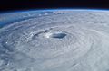
Hurricane Isabel (2003) as seen from orbit during Expedition 7 of the International Space Station. The eye, eyewall, and surrounding rainbands, characteristics of tropical cyclones in the narrow sense, are clearly visible in this view from space.
-
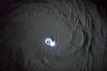
Thunderstorm activity in the eyewall of Cyclone Bansi as seen from the International Space Station, on January 12, 2015
-
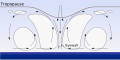
Tropical cyclones exhibit an overturning circulation where air inflows at low levels near the surface, rises in thunderstorm clouds, and outflows at high levels near the tropopause.
-
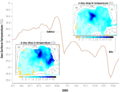
Chart displaying the drop in surface temperature in the Gulf of Mexico as Hurricanes Katrina and Rita passed over
-
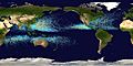
Map of the cumulative tracks of all tropical cyclones during the 1985–2005 time period. The Pacific Ocean west of the International Date Line sees more tropical cyclones than any other basin, while there is almost no activity in the southern hemisphere between Africa and 160˚W.
-
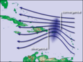
Waves in the trade winds in the Atlantic Ocean—areas of converging winds that move along the same track as the prevailing wind—create instabilities in the atmosphere that may lead to the formation of hurricanes.
-
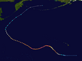
Storm track of Typhoon Ioke, showing recurvature off the Japanese coast in 2006
-
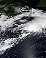
Tropical Storm Kyle, in 2020, is an example of a sheared tropical cyclone, with deep convection a couple hundred miles removed from the center of the system.
-
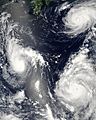
Three tropical cyclones of the 2006 Pacific typhoon season at different stages of development. The weakest (left) demonstrates only the most basic circular shape. A stronger storm (top right) demonstrates spiral banding and increased centralization, while the strongest (lower right) has developed an eye.
-
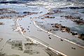
Flooding after the 1991 Bangladesh cyclone, which killed around 140,000 people.
-
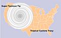
The relative sizes of Typhoon Tip, Cyclone Tracy, and the Contiguous United States
-
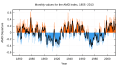
Atlantic Multidecadal Oscillation Timeseries, 1856–2013


See also
 In Spanish: Ciclón tropical para niños
