
Macquarie Island facts for kids
Quick facts for kids Macquarie Island * |
|
|---|---|

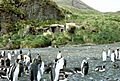
A shipwreck on Macquarie Island, 1911
|
|
| Country | Australia |
| Type | Natural |
| Criteria | vii, viii |
| Reference | 629 |
| Region ** | Asia-Pacific |
| Inscription history | |
| Inscription | 1997 (21st Session) |
|
|
Macquarie Island is a large island in the Southern Ocean. It is about 1,500 km (932 mi) south east of Tasmania, and about half way between Australia and Antarctica. The island became a UNESCO World Heritage Site in 1992. Macquarie Island is about 34 km (21 mi) long and 5 km (3 mi) wide. It was first discovered in July 1810, by Captain Hasselburgh, who was searching for places to hunt whales and seals. No people live there now. The only way to get to the island is by sea and there are no harbors to dock a ship.
Geology
The island was formed by two tectonic plates meeting and forcing each other upwards. It is the only place on Earth where rocks from the Earth's mantle, 6 km (4 mi) below the ocean floor, are being pushed up above sea level. Details are in this reference under section "Criterion (viii)".
Plants and animals
Many birds and animals use Macquarie Island to breed. About 3.5 million seabirds and 80,000 elephant seals come to the island every year. Four types of penguins live on the island. There are about 850,000 royal penguins, 200,000 king penguins, 10,000 gentoo penguins, and rockhopper penguins with numbers thought to be between 20,000 and 1,000,000.
In 1977 Macquarie Island became a Biosphere Reserve. The coastal ecosystem is recognized as part of UNESCO's Man and the Biosphere (MAB) Programme.
Related pages
Images for kids
-
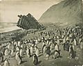
Penguins and remains of the wreck of "The Gratitude", Nuggets Beach, Macquarie Island, 1911, Frank Hurley
-
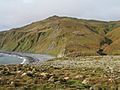
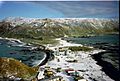
Macquarie Island bluffs
-
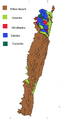
Simplified geological map
-
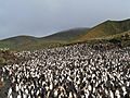
A royal penguin rookery on Macquarie Island
-
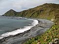
A Macquarie Island beach
-
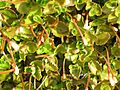
Macquarie Island flora, Epilobium pedunculare
-
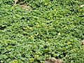
Macquarie Island flora, Stilbocarpa polaris
-
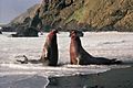
Bull elephant seal fighting
-
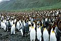
King penguin Lusitania Bay
-
Macquarie Island Station
-
Green Gorge Hut
-
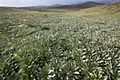
Highland herbfield dominated by Pleurophyllum hookeri
.jpg)


See also
 In Spanish: Isla Macquarie para niños
