
San Felipe de Puerto Plata facts for kids
Quick facts for kids
Puerto Plata
|
||
|---|---|---|
|
Municipality
|
||
| San Felipe de Puerto Plata | ||

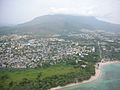
View from the air of Puerto Plata and the Isabel de Torres mountain
|
||
|
||
| Country | ||
| Province | Puerto Plata | |
| Founded | 1502 | |
| Municipality since | 1844 |
|
| Municipal Districts | Yásica Arriba, Maimón | |
| Area | ||
| • Total | 210.7 km2 (81.4 sq mi) | |
| • Urban | 31.96 km2 (12.34 sq mi) | |
| Elevation | 8 m (26 ft) | |
| Population
(2014)
|
||
| • Total | 128,240 | |
| • Density | 608.64/km2 (1,576.4/sq mi) | |
| • Urban | 118,496 | |
| Demonym(s) | Puertoplateño (female, puertoplateña) | |
| Time zone | UTC-4 (AST) | |
| • Summer (DST) | UTC-4 (AST) | |
| Distance: | 69 km (43 mi) to Santiago 215 km (134 mi) to Santo Domingo |
|

The Dominican city of San Felipe de Puerto Plata, usually called just Puerto Plata is the head municipality of the Puerto Plata province, on the north (Atlantic) coast of the country.
Name
The name Puerto Plata ("Silver Port") came from the name given by Columbus to the mountain just to the south of the city: Monte de Plata ("Silver Mountain") because the mountain always had clouds on its top and not because there was the metal silver; that mountain now is called Isabel de Torres mountain (in Spanish, the complete name is Loma Isabel de Torres). Isabel de Torres was a lady who lived in Puerto Plata in 1605 and had a lot of land in the mountain.
The city was called first Puerto de Plata but later it was changed to just Puerto Plata, the name that is still used
History

Columbus visited the Puerto Plata Bay on 11 January 1493. The city was founded and built by Nicolás de Ovando in 1502. Soon it became the most important port in the northern coast of the Hispaniola island and, in 1508, the king of Spain gave a coat of arms to the city.
Because there were many pirates and other British and French ships along the northern coast of the island, a fort was built here by orders of Carlos I, king of Spain; its construction took several years and it was finished in 1577. Because at that moment the Spanish's king was Felipe II, the fort was named Fuerte San Felipe (in English, Saint Phillip Fort).
In 1606, those that were living in the towns of Puerto Plata and Monte Cristi were ordered by the Spanish king to move to the southeast of the island and to found a new town: Monte Plata. Puerto Plata and Monte Cristi were, then, destroyed. They were founded again in the 18th century with families that came from the Canary Islands.
Population
The municipality had, in 2014, a total population of 128,240: 63,564 men and 64,676 women. The urban population was 92.4% of the total population.
Geography
San Felipe de Puerto Plata has a total area of 210.7 km2 (81 sq mi) (without including its municipal districts), about 11.7% of the total area of the province of Puerto Plata. The city is at an elevation of 8 m (26 ft), and at 215 km (134 mi) to the north of Santo Domingo.
The Cordillera Septentrional ("Northern mountain range") runs along the southern half of the municipality. There are only two roads that go through this mountain range. It rains a lot in these mountains.
The mountain "Loma Isabel de Torres" (the "Monte de Plata" of Columbus) is at about 5 km (3.1 mi) to the southeast of the city of Puerto Plata. It stands alone even if it is part of the Cordillera Septentrional. On top of the mountain, there is rainforest because it gets a lot of rain there; it rains almost every day. That forest is now a national park. It is 799 m (2,621 ft) high and there are two ways for getting to the top: by road or by a cable car (a type of car that runs on cables above the car).
There are many rivers in the municipality but, because the Cordillera Septentrional is close to the coast, they are all very short. The two most important rivers are Camú del Norte and Yásica. Two small rivers that are close to the city are San Marcos and Muñoz.
There are some bays along the coast. Two of them are the Puerto Plata Bay and Maimón Bay.
Climate
Puerto Plata has a tropical wet climate (Köppen-Geiger classification: Af) with no dry or cold season as it is constantly moist (rainfalls during the whole year).
The average amount of rainfall for the year in the city is 1,926 mm (75.8 in). The month with the most precipitation on average is December with 307 mm (12.1 in) of rainfall, followed by November with 283 mm (11.1 in).
The driest season is summer. The month with the least rainfall on average is July with an average of 78 mm (3.1 in) and the second is June with 82 mm (3.2 in).
Puerto Plata is in a warm region; the average temperature for the year is 25 °C (77.0 °F). The warmest month, on average, is July with an average temperature of 27 °C (80.6 °F). The coolest month on average is February, with an average temperature of 22.5 °C (72.5 °F).
| Climate data for Puerto Plata (1961–1990) | |||||||||||||
|---|---|---|---|---|---|---|---|---|---|---|---|---|---|
| Month | Jan | Feb | Mar | Apr | May | Jun | Jul | Aug | Sep | Oct | Nov | Dec | Year |
| Average high °C (°F) | 27 (81) |
27 (81) |
28 (82) |
29 (84) |
29 (84) |
31 (88) |
31 (88) |
31 (88) |
31 (88) |
31 (88) |
29 (84) |
28 (82) |
29 (85) |
| Daily mean °C (°F) | 23 (73) |
22.5 (72.5) |
23.5 (74.3) |
24.5 (76.1) |
25 (77) |
26.5 (79.7) |
27 (81) |
27 (81) |
26.5 (79.7) |
26.5 (79.7) |
25 (77) |
23.5 (74.3) |
25.0 (77.1) |
| Average low °C (°F) | 19 (66) |
18 (64) |
19 (66) |
20 (68) |
21 (70) |
22 (72) |
23 (73) |
23 (73) |
22 (72) |
22 (72) |
21 (70) |
19 (66) |
21 (69) |
| Average rainfall mm (inches) | 209 (8.2) |
162 (6.4) |
134 (5.3) |
160 (6.3) |
168 (6.6) |
82 (3.2) |
78 (3.1) |
88 (3.5) |
97 (3.8) |
158 (6.2) |
283 (11.1) |
307 (12.1) |
1,926 (75.8) |
| Source: Climatemps.com | |||||||||||||
Administrative division
The municipality of San Felipe de Puerto Plata has two municipal districts:
| Code | Municipal district | Population (2010) |
|---|---|---|
| 180102 | Yásica Arriba | 8,791 |
| 180103 | Maimón | 21,725 |
| Provincial capitals of the Dominican Republic | |
|---|---|
| Azua • Baní • Barahona • Bonao • Comendador • Cotuí • Dajabón • El Seibo • Hato Mayor • Higüey • Jimaní • La Romana • La Vega • Mao • Moca • Monte Cristi • Monte Plata • Nagua • Neiba • Pedernales • Puerto Plata • Sabaneta • Salcedo • Samaná • San Cristóbal • San Francisco de Macorís • San José de Ocoa • San Juan de la Maguana • San Pedro de Macorís • Santiago de los Caballeros • Santo Domingo • Santo Domingo Este | |
Images for kids
-
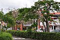
View of Puerto Plata
-
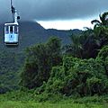
Tramway of Puerto Plata
-
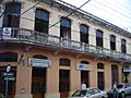
Puerto Plata post office
-
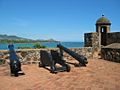
The Atlantic from Fortaleza San Felipe
-
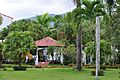
Puerto Plata, Dominican Republic streets.
-
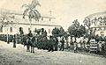
Puerto Plata in 1900.
-
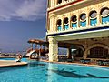
Puerto Plata resort area.
-
Ocean World Cofresi - Puerto Plata
-
Christ the Redeemer statue - Puerto Plata


.jpg)

.jpg)


See also
 In Spanish: Puerto Plata para niños
