
Afar Region facts for kids
Quick facts for kids
Afar Regional State
ዓፋር
Qafár Rakaakayih Doolata |
|||
|---|---|---|---|
|
Regional State
|
|||
|
|||

Map of Ethiopia showing Afar Region
|
|||
| Country | Ethiopia | ||
| Capital | Semera | ||
| Area | |||
| • Total | 72,053 km2 (27,820 sq mi) | ||
| Population
(2017)
|
|||
| • Total | 1,812,002 | ||
| • Density | 25.14818/km2 (65.1335/sq mi) | ||
| ISO 3166 code | ET-AF | ||


The Afar Regional State is a special part of Ethiopia. It's one of the nine main regions in the country. This region is where the Afar people live. Its main city, or capital, is Semera.
Contents
Discovering Afar's Unique Landscape
In the north of Afar, you'll find the amazing Danakil Depression. This place is super low, actually the lowest point in all of Ethiopia! It's also one of the lowest spots in Africa. Imagine a place below sea level!
The Awash River flows through the southern part of the region. It creates a green valley in an otherwise dry area. You can also visit cool places like Awash National Park and Yangudi Rassa National Park here. These parks are home to many different animals.
How Afar is Organized
Afar is split into smaller areas called administrative zones. Think of them like different counties or districts within the region. There's also one special area called a woreda.
Afar's Administrative Zones
- Administrative Zone 1: Awsi Rasu
- Administrative Zone 2: Kilbati Rasu
- Administrative Zone 3: Gabi Rasu
- Administrative Zone 4: Fanti Rasu
- Administrative Zone 5: Harri Rasu
- Argobba special woreda
Images for kids
-
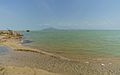
Afdera Lake
-
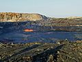
Erta Ale Volcano

.jpg)
See also
 In Spanish: Región Afar para niños
