Alaska water resource region facts for kids
The Alaska water resource region is one of 21 big areas in the United States that scientists use to study water. These areas are like giant natural bowls where all the rain and snow eventually flow into a main river or a group of rivers.
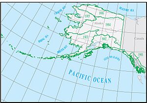
The Alaska region is special because it covers all the land in Alaska where water flows. It's known by a special code, HUC 19, and it's huge! It covers about 720,535 square miles (1,866,180 square kilometers). This big region is then split into 6 smaller parts, called subregions, each with its own HUC code from 1901 to 1906.
Alaska's Water Subregions
Scientists divide Alaska into six main water subregions. Each subregion has its own unique features and rivers. These divisions help us understand how water flows across the state and how different areas are connected by their water systems.
Exploring Alaska's Water Areas
Here's a look at the six water subregions in Alaska:
| Subregion Code | Subregion Name | What it Covers | Size | Map |
|---|---|---|---|---|
| 1901 | Arctic Slope subregion | This area covers the northern part of Alaska. All the water here flows north into the Arctic Ocean. It stretches from the border with Canada all the way to Cape Lisburne. | 81,000 sq mi (210,000 km2) | |
| 1902 | Northwest Alaska subregion | This subregion is along the northwest coast of Alaska. Its water flows into the bays and sounds of the Bering Sea. It also includes St. Lawrence Island. | 75,000 sq mi (190,000 km2) | |
| 1903 | Yukon subregion | This is the largest subregion. It includes all the land in Alaska where water flows into the mighty Yukon River, including its wide delta where it meets the sea. | 204,000 sq mi (530,000 km2) | |
| 1904 | Southwest Alaska subregion | This area covers the southwest coast of Alaska. Water here flows into the Bering Sea and the Pacific Ocean. It includes many islands like St. Matthew, Nunivak, Pribilof, and all the Aleutian Islands. | 124,000 sq mi (320,000 km2) | |
| 1905 | South Central Alaska subregion | This subregion is in south-central Alaska. Its water flows into the Pacific Ocean. It includes many bays, islands, and sounds along the coast. | 99,000 sq mi (260,000 km2) | |
| 1906 | Southeast Alaska subregion | This area covers the narrow strip of land and islands in southeast Alaska. Water here flows into the Pacific Ocean, stretching from Point Riou to the border with British Columbia, Canada. | 49,000 sq mi (130,000 km2) |
 | William M. Jackson |
 | Juan E. Gilbert |
 | Neil deGrasse Tyson |


