Argleton facts for kids
Argleton was the name of a village that didn't actually exist. It was a "phantom settlement" that appeared on Google Maps for a while. This made it a mystery! It was shown near a real village called Aughton, Lancashire, in England.
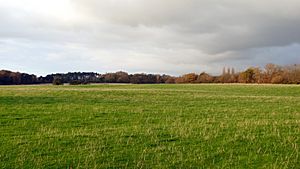
In 2008, someone working at Edge Hill University noticed Argleton on Google Maps. They checked the location and found only empty fields, not a village.
What Was Argleton?
Argleton was a place that appeared on digital maps but wasn't real. These kinds of places are sometimes called "phantom settlements" or "paper towns." They are like a ghost on a map.
- It was located in the parish of Aughton, Lancashire, England.
- It showed up on Google Maps, a popular online mapping service.
- When people went to the spot, they found only open land.
The Mystery of Argleton
People wondered why Argleton was on Google Maps. There were a few ideas about how it got there.
- A Mistake: One idea was that it was simply a mistake. Mapping software can sometimes have errors. A typo or a glitch might have put Argleton on the map by accident.
- A Trap: Another idea was that Google put it there on purpose. Some mapmakers add fake places to their maps. This helps them catch other companies who might try to copy their work. If another map showed Argleton, it would prove they copied Google's map. This is a way to protect their work from being copied.
When Did Argleton Disappear?
Argleton was removed from Google Maps by May 2010. This meant the mystery village was gone from the digital world. It remains an interesting story about how maps can sometimes show things that aren't really there.
See also
 In Spanish: Argleton para niños


